
Topografische Karte Bass Island
Interaktive Karte
Klicken Sie auf die Karte, um die Höhe anzuzeigen.
Über diese Karte
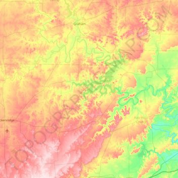
Name: Topografische Karte Bass Island, Höhe, Relief.
Ort: Bass Island, Palo Pinto County, Texas, United States (32.54623 -98.86089 33.18623 -98.22089)
Durchschnittliche Höhe: 357 m
Minimale Höhe: 232 m
Maximale Höhe: 493 m
Andere topografische Karten
Klicken Sie auf eine Karte, um ihre Topografie, ihre Höhe und ihr Relief anzuzeigen.
Roundtop Mountain
United States > Texas > Palo Pinto County
Roundtop Mountain, Palo Pinto County, Texas, 76463, United States
Durchschnittliche Höhe: 320 m
Possum Kingdom Lake
United States > Texas > Palo Pinto County
Possum Kingdom Lake, Palo Pinto County, Texas, United States
Durchschnittliche Höhe: 334 m
Santo
United States > Texas > Palo Pinto County > Santo
Santo, Palo Pinto County, Texas, United States
Durchschnittliche Höhe: 264 m
Mineral Wells
United States > Texas > Palo Pinto County > Mineral Wells
Mineral Wells, Palo Pinto County, Texas, 76067, United States
Durchschnittliche Höhe: 294 m