Geolokalisieren

Topografische Karte Harper County

Klicken Sie auf die Karte, um die Höhe anzuzeigen.

Über diese Karte

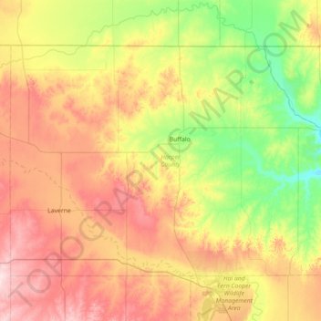
Name: Topografische Karte Harper County, Höhe, Relief.

Ort: Harper County, Oklahoma, United States (36.59316 -100.00442 37.00177 -99.29489)

Durchschnittliche Höhe: 610 m

Minimale Höhe: 488 m

Maximale Höhe: 776 m

Andere topografische Karten

Klicken Sie auf eine Karte, um ihre Topografie, ihre Höhe und ihr Relief anzuzeigen.

Oklahoma City

United States > Oklahoma > Oklahoma County > Oklahoma City

Durchschnittliche Höhe: 370 m

Owasso

United States > Oklahoma > Tulsa County > Owasso > Owasso

Durchschnittliche Höhe: 193 m

Broken Bow Lake

United States > Oklahoma > McCurtain County

Durchschnittliche Höhe: 158 m

Ross Lake

United States > Oklahoma > Muskogee County > Fort Gibson

Durchschnittliche Höhe: 156 m

Hochatown

United States > Oklahoma > McCurtain County

Durchschnittliche Höhe: 220 m

Tombstone Mountain

United States > Oklahoma > Le Flore County

Durchschnittliche Höhe: 456 m

Redden

United States > Oklahoma > Atoka County

Durchschnittliche Höhe: 220 m

Elk Mountain

United States > Oklahoma > Comanche County

Durchschnittliche Höhe: 543 m

Macomb

United States > Oklahoma > Pottawatomie County > Macomb

Durchschnittliche Höhe: 298 m

Douthat

United States > Oklahoma > Ottawa County > Picher

Durchschnittliche Höhe: 249 m

Wesley

United States > Oklahoma > Atoka County

Durchschnittliche Höhe: 250 m

Limestone Gap

United States > Oklahoma > Atoka County

Durchschnittliche Höhe: 232 m

Hopewell

United States > Oklahoma > Atoka County

Durchschnittliche Höhe: 219 m

Farris

United States > Oklahoma > Atoka County

Durchschnittliche Höhe: 163 m

Chockie

United States > Oklahoma > Atoka County

Durchschnittliche Höhe: 221 m

Daisy

United States > Oklahoma > Atoka County

Durchschnittliche Höhe: 251 m

Boggy Depot State Park

United States > Oklahoma > Atoka County

Durchschnittliche Höhe: 177 m

Wardville

United States > Oklahoma > Atoka County

Durchschnittliche Höhe: 210 m

Bentley

United States > Oklahoma > Atoka County

Durchschnittliche Höhe: 165 m

Baron

United States > Oklahoma > Adair County

Durchschnittliche Höhe: 296 m

Bunch

United States > Oklahoma > Adair County

Durchschnittliche Höhe: 285 m

Olive

United States > Oklahoma > Creek County

Durchschnittliche Höhe: 276 m

Carpenter

United States > Oklahoma > Roger Mills County

Durchschnittliche Höhe: 597 m

Milfay

United States > Oklahoma > Creek County

Durchschnittliche Höhe: 248 m

White Oak

United States > Oklahoma > Craig County

Durchschnittliche Höhe: 232 m

Swink

United States > Oklahoma > Choctaw County

Durchschnittliche Höhe: 152 m

Apple

United States > Oklahoma > Choctaw County

Durchschnittliche Höhe: 135 m

Fallon

United States > Oklahoma > Choctaw County

Durchschnittliche Höhe: 143 m

Frogville

United States > Oklahoma > Choctaw County

Durchschnittliche Höhe: 124 m

Gay

United States > Oklahoma > Choctaw County

Durchschnittliche Höhe: 136 m

Hamden

United States > Oklahoma > Choctaw County

Durchschnittliche Höhe: 158 m

Messer

United States > Oklahoma > Choctaw County

Durchschnittliche Höhe: 137 m

Nelson

United States > Oklahoma > Choctaw County

Durchschnittliche Höhe: 183 m

Spencerville

United States > Oklahoma > Choctaw County

Durchschnittliche Höhe: 158 m

Graham

United States > Oklahoma > Carter County

Durchschnittliche Höhe: 287 m

Tussy

United States > Oklahoma > Carter County

Durchschnittliche Höhe: 297 m

Countyline

United States > Oklahoma > Stephens County

Durchschnittliche Höhe: 310 m

Scott

United States > Oklahoma > Caddo County

Durchschnittliche Höhe: 483 m

Sugar Mountain

United States > Oklahoma > Cherokee County

Durchschnittliche Höhe: 289 m

Sperry

United States > Oklahoma > Tulsa County

Durchschnittliche Höhe: 191 m

McQueen

United States > Oklahoma > Harmon County

Durchschnittliche Höhe: 464 m

McKnight

United States > Oklahoma > Harmon County

Durchschnittliche Höhe: 529 m

Madge

United States > Oklahoma > Harmon County

Durchschnittliche Höhe: 583 m

Hennepin

United States > Oklahoma > Garvin County

Durchschnittliche Höhe: 289 m

Pernell

United States > Oklahoma > Garvin County

Durchschnittliche Höhe: 307 m

Purdy

United States > Oklahoma > Garvin County

Durchschnittliche Höhe: 329 m

Wallville

United States > Oklahoma > Garvin County

Durchschnittliche Höhe: 318 m

Hillsdale

United States > Oklahoma > Garfield County > Hillsdale

Durchschnittliche Höhe: 375 m

Brinkman

United States > Oklahoma > Greer County

Durchschnittliche Höhe: 520 m

Hester

United States > Oklahoma > Greer County

Durchschnittliche Höhe: 448 m

Boone

United States > Oklahoma > Caddo County

Durchschnittliche Höhe: 426 m

Lake Lawtonka

United States > Oklahoma > Comanche County

Durchschnittliche Höhe: 428 m

Meers

United States > Oklahoma > Comanche County

Durchschnittliche Höhe: 457 m

Box

United States > Oklahoma > Sequoyah County

Durchschnittliche Höhe: 269 m

Briartown

United States > Oklahoma > Muskogee County

Durchschnittliche Höhe: 172 m

Trestle Ford

United States > Oklahoma > Le Flore County

Durchschnittliche Höhe: 187 m

Chloeta

United States > Oklahoma > Delaware County

Durchschnittliche Höhe: 263 m

Rose

United States > Oklahoma > Mayes County

Durchschnittliche Höhe: 300 m

Spavinaw

United States > Oklahoma > Mayes County

Durchschnittliche Höhe: 240 m

Centerview

United States > Oklahoma > Pottawatomie County

Durchschnittliche Höhe: 293 m

Welty

United States > Oklahoma > Okfuskee County

Durchschnittliche Höhe: 227 m

Little

United States > Oklahoma > Seminole County

Durchschnittliche Höhe: 288 m

Vanoss

United States > Oklahoma > Pontotoc County

Durchschnittliche Höhe: 314 m

Fox

United States > Oklahoma > Carter County

Durchschnittliche Höhe: 299 m

Milo

United States > Oklahoma > Carter County

Durchschnittliche Höhe: 276 m

Pooleville

United States > Oklahoma > Carter County

Durchschnittliche Höhe: 318 m

Harjo

United States > Oklahoma > Pottawatomie County

Durchschnittliche Höhe: 284 m

Trousdale

United States > Oklahoma > Pottawatomie County

Durchschnittliche Höhe: 304 m

Antioch

United States > Oklahoma > Marshall County

Durchschnittliche Höhe: 269 m

Hoyt

United States > Oklahoma > Haskell County

Durchschnittliche Höhe: 170 m

Enterprise

United States > Oklahoma > Haskell County

Durchschnittliche Höhe: 214 m

Joy

United States > Oklahoma > Murray County

Durchschnittliche Höhe: 264 m

Petersburg

United States > Oklahoma > Jefferson County

Durchschnittliche Höhe: 251 m

Oscar

United States > Oklahoma > Jefferson County

Durchschnittliche Höhe: 260 m

Grady

United States > Oklahoma > Jefferson County

Durchschnittliche Höhe: 258 m

Orienta

United States > Oklahoma > Major County

Durchschnittliche Höhe: 380 m

Omega

United States > Oklahoma > Kingfisher County

Durchschnittliche Höhe: 367 m

Moorewood

United States > Oklahoma > Custer County

Durchschnittliche Höhe: 557 m

Berlin

United States > Oklahoma > Roger Mills County

Durchschnittliche Höhe: 645 m

Dempsey

United States > Oklahoma > Roger Mills County

Durchschnittliche Höhe: 733 m

Balko

United States > Oklahoma > Beaver County

Durchschnittliche Höhe: 860 m

Big Cedar

United States > Oklahoma > Le Flore County

Durchschnittliche Höhe: 305 m

Academic Hights

United States > Oklahoma > Comanche County > Lawton

Durchschnittliche Höhe: 348 m

Mount Scott

United States > Oklahoma > Comanche County

Durchschnittliche Höhe: 496 m

University

United States > Oklahoma > Oklahoma County > Oklahoma City

Durchschnittliche Höhe: 377 m

Woodward, Oklahoma

United States > Oklahoma > Woodward County > Woodward

Durchschnittliche Höhe: 590 m

Comanche

United States > Oklahoma > Comanche County

Durchschnittliche Höhe: 368 m

Cabaniss

United States > Oklahoma > Pittsburg County

Durchschnittliche Höhe: 236 m

Okmulgee

United States > Oklahoma > Okmulgee County

Durchschnittliche Höhe: 204 m

Winchester

United States > Oklahoma > Winchester

Durchschnittliche Höhe: 451 m

Turpin

United States > Oklahoma > Beaver County > Turpin

Durchschnittliche Höhe: 836 m

Cross Mountain

United States > Oklahoma > Comanche County

Durchschnittliche Höhe: 530 m

Terrace Park

United States > Oklahoma > Tulsa County > Tulsa

Durchschnittliche Höhe: 224 m

Sayre

United States > Oklahoma > Beckham County > Sayre > Sayre

Sayre is located at 35°17′56″N 99°38′12″W / 35.29889°N 99.63667°W / 35.29889; -99.63667 (35.298940, -99.636556). It is located on the North Fork of the Red River, at an elevation of 1,800 feet (550 m) and 128 miles (206 km) west of Oklahoma City. The area is dominated by low rolling red clay hills.

Durchschnittliche Höhe: 560 m

Stillwater

United States > Oklahoma > Payne County > Stillwater

Durchschnittliche Höhe: 295 m

Chandler Lake

United States > Oklahoma > Lincoln County > Chandler

Durchschnittliche Höhe: 283 m

Mount McKinley

United States > Oklahoma > Comanche County

Durchschnittliche Höhe: 498 m

Rüste dich für dein nächstes Abenteuer:

🧢Sonnenhüte & Caps - Kopfbedeckungen mit UV‑Schutz für lange Tage draußen
🧗‍♂️Grundausrüstung Klettern - Klettergurte, Karabiner und Zubehör für Einsteiger
🧵Paracord-Schnüre - Vielseitige Leine für Reparaturen und Notfälle
🧯Gaskartuschen & Zubehör - Brennstoff für Outdoor‑Kocher
🧭Karten‑ & Kompass‑Sets - Kombipakete für klassische Navigation

Als Amazon-Partner verdient diese Seite an qualifizierten Käufen, ohne dass Ihnen zusätzliche Kosten entstehen.