
Topografische Karte Fraser
Interaktive Karte
Klicken Sie auf die Karte, um die Höhe anzuzeigen.
Über diese Karte
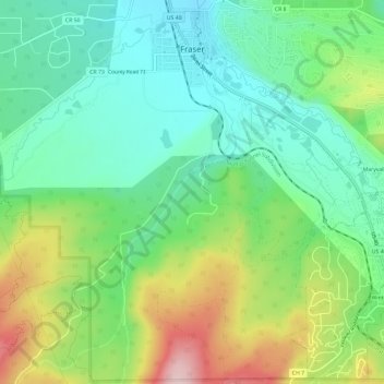
Name: Topografische Karte Fraser, Höhe, Relief.
Ort: Fraser, Grand County, Colorado, 80442, United States (39.90779 -105.82230 39.95298 -105.77621)
Durchschnittliche Höhe: 2’696 m
Minimale Höhe: 2’599 m
Maximale Höhe: 2’888 m
Fraser is located in southeastern Grand County at 39°56′39″N 105°48′48″W / 39.94417°N 105.81333°W / 39.94417; -105.81333 (39.944158, -105.813355), at an elevation of 8,574 feet (2,613 m) above sea level. It is bordered to the south by the town of Winter Park and to the north by unincorporated Tabernash. U.S. Route 40 leads south and east across Berthoud Pass 71 miles (114 km) to Denver, and northwest 15 miles (24 km) to Granby, the largest town in Grand County.
Andere topografische Karten
Klicken Sie auf eine Karte, um ihre Topografie, ihre Höhe und ihr Relief anzuzeigen.
Grand Lake
United States > Colorado > Grand County
Grand Lake, Grand County, Colorado, United States
Durchschnittliche Höhe: 2’630 m
Morse Mountain
United States > Colorado > Grand County
Morse Mountain, Grand County, Colorado, United States
Durchschnittliche Höhe: 2’924 m
Winter Park
United States > Colorado > Grand County
Winter Park, Grand County, Colorado, United States
Durchschnittliche Höhe: 3’068 m
Lake Granby
United States > Colorado > Grand County
Lake Granby, Grand County, Colorado, United States
Durchschnittliche Höhe: 2’608 m
Granby
United States > Colorado > Grand County
Granby, Grand County, Colorado, United States
Durchschnittliche Höhe: 2’555 m
Rabbit Ears Pass
United States > Colorado > Grand County
Rabbit Ears Pass, Grand County, Colorado, United States
Durchschnittliche Höhe: 2’852 m
Bottle Peak
United States > Colorado > Grand County
Bottle Peak, Grand County, Colorado, United States
Durchschnittliche Höhe: 3’283 m
Elk Mountain
United States > Colorado > Grand County
Elk Mountain, Grand County, Colorado, United States
Durchschnittliche Höhe: 3’218 m
Tabernash
United States > Colorado > Grand County
Tabernash, Grand County, Colorado, 80478, United States
Durchschnittliche Höhe: 2’592 m
Kremmling
United States > Colorado > Grand County
Kremmling, Grand County, Colorado, 80459, United States
Durchschnittliche Höhe: 2’251 m
Mount Flora
United States > Colorado > Grand County
Mount Flora, Grand County, Colorado, United States
Durchschnittliche Höhe: 3’728 m
Indian Peaks Wilderness
United States > Colorado > Grand County
Indian Peaks Wilderness, Grand County, Colorado, United States
Durchschnittliche Höhe: 3’080 m