
Topografische Karte Indian Peaks Wilderness
Interaktive Karte
Klicken Sie auf die Karte, um die Höhe anzuzeigen.
Über diese Karte
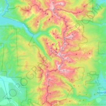
Name: Topografische Karte Indian Peaks Wilderness, Höhe, Relief.
Durchschnittliche Höhe: 3’080 m
Minimale Höhe: 2’492 m
Maximale Höhe: 4’096 m
The area encompasses a stretch of the Front Range. It includes 7 peaks over 13,000 feet (4,000 m) in elevation. The highest point is North Arapaho Peak at 13,502 feet (4,115 m). The peaks are all within 100 feet (30 m) of elevation of each other. A portion of the area, encompassing the headwaters of North Boulder Creek, is closed to the public as it is the City of Boulder watershed.
Andere topografische Karten
Klicken Sie auf eine Karte, um ihre Topografie, ihre Höhe und ihr Relief anzuzeigen.
Grand Lake
United States > Colorado > Grand County
Grand Lake, Grand County, Colorado, United States
Durchschnittliche Höhe: 2’630 m
Morse Mountain
United States > Colorado > Grand County
Morse Mountain, Grand County, Colorado, United States
Durchschnittliche Höhe: 2’924 m
Fraser
United States > Colorado > Grand County
Fraser, Grand County, Colorado, 80442, United States
Durchschnittliche Höhe: 2’696 m
Winter Park
United States > Colorado > Grand County
Winter Park, Grand County, Colorado, United States
Durchschnittliche Höhe: 3’068 m
Lake Granby
United States > Colorado > Grand County
Lake Granby, Grand County, Colorado, United States
Durchschnittliche Höhe: 2’608 m
Granby
United States > Colorado > Grand County
Granby, Grand County, Colorado, United States
Durchschnittliche Höhe: 2’555 m
Rabbit Ears Pass
United States > Colorado > Grand County
Rabbit Ears Pass, Grand County, Colorado, United States
Durchschnittliche Höhe: 2’852 m
Bottle Peak
United States > Colorado > Grand County
Bottle Peak, Grand County, Colorado, United States
Durchschnittliche Höhe: 3’283 m
Elk Mountain
United States > Colorado > Grand County
Elk Mountain, Grand County, Colorado, United States
Durchschnittliche Höhe: 3’218 m
Tabernash
United States > Colorado > Grand County
Tabernash, Grand County, Colorado, 80478, United States
Durchschnittliche Höhe: 2’592 m
Kremmling
United States > Colorado > Grand County
Kremmling, Grand County, Colorado, 80459, United States
Durchschnittliche Höhe: 2’251 m
Mount Flora
United States > Colorado > Grand County
Mount Flora, Grand County, Colorado, United States
Durchschnittliche Höhe: 3’728 m