
Topografische Karte Rabbit Ears Pass
Interaktive Karte
Klicken Sie auf die Karte, um die Höhe anzuzeigen.
Über diese Karte
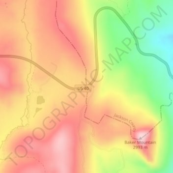
Name: Topografische Karte Rabbit Ears Pass, Höhe, Relief.
Ort: Rabbit Ears Pass, Grand County, Colorado, United States (40.38402 -106.61190 40.38412 -106.61180)
Durchschnittliche Höhe: 2’852 m
Minimale Höhe: 2’694 m
Maximale Höhe: 2’962 m
Although lower in elevation than many of the high mountain passes farther to the south in the Colorado Rockies, Rabbit Ears Pass often receives a great deal of snow in winter and is subject to regular short closures during heavy winter storms. The seasonal snowpack on this pass is a major source of water for residence in the nearby area. Rabbit Ears pass is a place for many different outdoor recreational activities. In the winter, it is a popular spot for back country snowboarding and skiing, cross-country skiing, and snowshoeing. There are boundaries set up to separate motorized use from foot traffic. These established boundaries decrease conflicts between users and seasonal closures related to snow depth and animal wintering ranges. Non-motorized recreation is permitted west of the pass and motorized recreation is permitted east of the pass. The boundary designating winter recreational usage on Rabbit Ears Pass provides an opportunity to study the influence of motorized recreation on the physical properties of the snowpack and animal use. The United States Department of Agriculture (USDA) Forest Service managing the Routt National Forest has not only implemented boundary regulations, but they have also put into effect regulatory practices designating the start of the snowmobile season when the unpacked snow depth equals or exceeds 30 cm (12 inches). There have been limited studies regarding the effectiveness of the current management plan with respect to an adequate snow depth that would minimize the potential impact motorized winter recreationalists have on this seasonal habitat.
Andere topografische Karten
Klicken Sie auf eine Karte, um ihre Topografie, ihre Höhe und ihr Relief anzuzeigen.
Grand Lake
United States > Colorado > Grand County
Grand Lake, Grand County, Colorado, United States
Durchschnittliche Höhe: 2’630 m
Morse Mountain
United States > Colorado > Grand County
Morse Mountain, Grand County, Colorado, United States
Durchschnittliche Höhe: 2’924 m
Fraser
United States > Colorado > Grand County
Fraser, Grand County, Colorado, 80442, United States
Durchschnittliche Höhe: 2’696 m
Winter Park
United States > Colorado > Grand County
Winter Park, Grand County, Colorado, United States
Durchschnittliche Höhe: 3’068 m
Lake Granby
United States > Colorado > Grand County
Lake Granby, Grand County, Colorado, United States
Durchschnittliche Höhe: 2’608 m
Granby
United States > Colorado > Grand County
Granby, Grand County, Colorado, United States
Durchschnittliche Höhe: 2’555 m
Bottle Peak
United States > Colorado > Grand County
Bottle Peak, Grand County, Colorado, United States
Durchschnittliche Höhe: 3’283 m
Elk Mountain
United States > Colorado > Grand County
Elk Mountain, Grand County, Colorado, United States
Durchschnittliche Höhe: 3’218 m
Tabernash
United States > Colorado > Grand County
Tabernash, Grand County, Colorado, 80478, United States
Durchschnittliche Höhe: 2’592 m
Kremmling
United States > Colorado > Grand County
Kremmling, Grand County, Colorado, 80459, United States
Durchschnittliche Höhe: 2’251 m
Mount Flora
United States > Colorado > Grand County
Mount Flora, Grand County, Colorado, United States
Durchschnittliche Höhe: 3’728 m
Indian Peaks Wilderness
United States > Colorado > Grand County
Indian Peaks Wilderness, Grand County, Colorado, United States
Durchschnittliche Höhe: 3’080 m