
Spenden
Rüste dich für dein nächstes Abenteuer:
Als Amazon-Partner verdient diese Seite an qualifizierten Käufen, ohne dass Ihnen zusätzliche Kosten entstehen.
Topografische Karte Chaozhou
Klicken Sie auf die Karte, um die Höhe anzuzeigen.
Spenden
Rüste dich für dein nächstes Abenteuer:
Als Amazon-Partner verdient diese Seite an qualifizierten Käufen, ohne dass Ihnen zusätzliche Kosten entstehen.
Chaozhou
The Chaozhou territory is mountainous. In particular, the nearby Phoenix Mountain's peak is located 1,497 meters (4,911 ft) above sea level. The main nearby rivers are the Huanggang River and the Han River. The Han River flows from west to southeast, and ramps through downtown Chaozhou; the Huanggang river flows roughly from north to south through the territory of Raoping, emptying into the sea. These two rivers provide abundant water for Chaozhou. Hills account for 65% of the total land area within the city, mainly in Raoping and Northern Chaoan. To the north of the city, there is a wide mountainous area suitable for tea cultivation; the lower-altitude areas nearby are mainly suitable for growing bamboo, peach, plum, olive, and pineapple. On the banks of the Han River, there is fertile land used for rice, sweet potato, peanut, soybean, carrot, orange, peach, and banana cultivation.
Spenden
Rüste dich für dein nächstes Abenteuer:
Als Amazon-Partner verdient diese Seite an qualifizierten Käufen, ohne dass Ihnen zusätzliche Kosten entstehen.
Über diese Karte
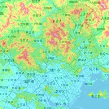
Name: Topografische Karte Chaozhou, Höhe, Relief.
Ort: Chaozhou, Guangdong, China (23.42758 116.36375 24.23576 117.22214)
Durchschnittliche Höhe: 229 m
Minimale Höhe: -1 m
Maximale Höhe: 1’501 m
Spenden
Rüste dich für dein nächstes Abenteuer:
Als Amazon-Partner verdient diese Seite an qualifizierten Käufen, ohne dass Ihnen zusätzliche Kosten entstehen.
Andere topografische Karten
Klicken Sie auf eine Karte, um ihre Topografie, ihre Höhe und ihr Relief anzuzeigen.
Spenden
Rüste dich für dein nächstes Abenteuer:
Als Amazon-Partner verdient diese Seite an qualifizierten Käufen, ohne dass Ihnen zusätzliche Kosten entstehen.
Mount Yangtai
The Mount Yangtai (Chinese: 羊台山; pinyin: Yángtaíshān), also known as Mount Yangtai Forest Park, is a mountain at the junction of Bao'an District and Nanshan District in Shenzhen, Guangdong, China. The peak is 587.3 metres (1,927 ft) in elevation, which is the highest peak in western Shenzhen. In 2008…
Durchschnittliche Höhe: 287 m
Spenden
Rüste dich für dein nächstes Abenteuer:
Als Amazon-Partner verdient diese Seite an qualifizierten Käufen, ohne dass Ihnen zusätzliche Kosten entstehen.
Spenden
Rüste dich für dein nächstes Abenteuer:
Als Amazon-Partner verdient diese Seite an qualifizierten Käufen, ohne dass Ihnen zusätzliche Kosten entstehen.
Spenden
Rüste dich für dein nächstes Abenteuer:
Als Amazon-Partner verdient diese Seite an qualifizierten Käufen, ohne dass Ihnen zusätzliche Kosten entstehen.