
Topografische Karte Fort Peck
Interaktive Karte
Klicken Sie auf die Karte, um die Höhe anzuzeigen.
Über diese Karte
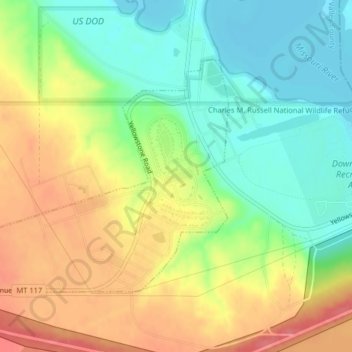
Name: Topografische Karte Fort Peck, Höhe, Relief.
Ort: Fort Peck, Valley County, Montana, United States (48.00077 -106.47954 48.01857 -106.44172)
Durchschnittliche Höhe: 652 m
Minimale Höhe: 618 m
Maximale Höhe: 693 m
Andere topografische Karten
Klicken Sie auf eine Karte, um ihre Topografie, ihre Höhe und ihr Relief anzuzeigen.
Fort Peck Lake
United States > Montana > Valley County
Fort Peck Lake, Valley County, Montana, 59223, United States
Durchschnittliche Höhe: 783 m
Dead Mans Hill
United States > Montana > Valley County
Dead Mans Hill, Valley County, Montana, United States
Durchschnittliche Höhe: 728 m
Glasgow
United States > Montana > Valley County > Glasgow
Glasgow, Valley County, Montana, 59230, United States
Durchschnittliche Höhe: 654 m