
Topografische Karte Dead Mans Hill
Interaktive Karte
Klicken Sie auf die Karte, um die Höhe anzuzeigen.
Über diese Karte
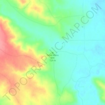
Name: Topografische Karte Dead Mans Hill, Höhe, Relief.
Ort: Dead Mans Hill, Valley County, Montana, United States (48.21440 -107.27875 48.21450 -107.27865)
Durchschnittliche Höhe: 728 m
Minimale Höhe: 695 m
Maximale Höhe: 783 m
Andere topografische Karten
Klicken Sie auf eine Karte, um ihre Topografie, ihre Höhe und ihr Relief anzuzeigen.
Fort Peck Lake
United States > Montana > Valley County
Fort Peck Lake, Valley County, Montana, 59223, United States
Durchschnittliche Höhe: 783 m
Glasgow
United States > Montana > Valley County > Glasgow
Glasgow, Valley County, Montana, 59230, United States
Durchschnittliche Höhe: 654 m
Fort Peck
United States > Montana > Valley County
Fort Peck, Valley County, Montana, United States
Durchschnittliche Höhe: 652 m