
Topografische Karte Warner
Interaktive Karte
Klicken Sie auf die Karte, um die Höhe anzuzeigen.
Über diese Karte
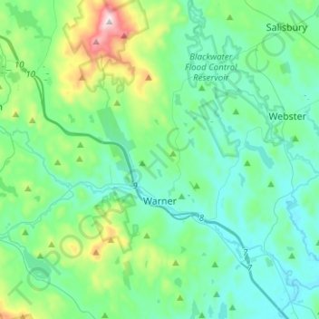
Name: Topografische Karte Warner, Höhe, Relief.
Ort: Warner, Merrimack County, New Hampshire, United States (43.21310 -71.92410 43.39525 -71.72581)
Durchschnittliche Höhe: 247 m
Minimale Höhe: 103 m
Maximale Höhe: 886 m
Mount Kearsarge, elevation 2,937 feet (895 m) above sea level, located in the extreme north of the town, is the highest point in Warner and in Merrimack County. Two state parks are located on the mountain: Rollins State Park in Warner and Winslow State Park in Wilmot. Mount Kearsarge is a popular hiking destination, due both to its bare, rocky summit, and to the fact that a paved road climbs from Rollins State Park to within a half mile of the summit. The peak is the highest point along the 75-mile (121 km) Sunapee-Ragged-Kearsarge Greenway, a hiking trail which links ten towns and encircles the Lake Sunapee region of western New Hampshire.
Andere topografische Karten
Klicken Sie auf eine Karte, um ihre Topografie, ihre Höhe und ihr Relief anzuzeigen.
Wilmot
United States > New Hampshire > Merrimack County
Wilmot, Merrimack County, New Hampshire, United States
Durchschnittliche Höhe: 364 m
New London
United States > New Hampshire > Merrimack County
New London, Merrimack County, New Hampshire, United States
Durchschnittliche Höhe: 365 m
Suncook
United States > New Hampshire > Merrimack County > Pembroke
Suncook, Pembroke, Merrimack County, New Hampshire, 03275, United States
Durchschnittliche Höhe: 93 m
Bow
United States > New Hampshire > Merrimack County
Bow, Merrimack County, New Hampshire, 03304, United States
Durchschnittliche Höhe: 152 m
Henniker
United States > New Hampshire > Merrimack County
Henniker, Merrimack County, New Hampshire, 03242, United States
Durchschnittliche Höhe: 223 m
Dunbarton
United States > New Hampshire > Merrimack County
Dunbarton, Merrimack County, New Hampshire, 03046, United States
Durchschnittliche Höhe: 167 m
Riverhill
United States > New Hampshire > Merrimack County > Concord
Riverhill, Concord, Merrimack County, New Hampshire, 03303, United States
Durchschnittliche Höhe: 140 m
Andover
United States > New Hampshire > Merrimack County > Andover
Andover, Merrimack County, New Hampshire, United States
Durchschnittliche Höhe: 301 m
Hooksett
United States > New Hampshire > Merrimack County
Hooksett, Merrimack County, New Hampshire, 03106, United States
Durchschnittliche Höhe: 130 m
Pembroke
United States > New Hampshire > Merrimack County
Pembroke, Merrimack County, New Hampshire, 03275, United States
Durchschnittliche Höhe: 131 m
Rings Corner
United States > New Hampshire > Merrimack County > Pittsfield > Rings Corner
Rings Corner, Pittsfield, Merrimack County, New Hampshire, 03274, United States
Durchschnittliche Höhe: 190 m
Hopkinton
United States > New Hampshire > Merrimack County
Hopkinton, Merrimack County, New Hampshire, 03229, United States
Durchschnittliche Höhe: 146 m
Pittsfield
United States > New Hampshire > Merrimack County
Pittsfield, Merrimack County, New Hampshire, 03263, United States
Durchschnittliche Höhe: 201 m
Loudon
United States > New Hampshire > Merrimack County
Loudon, Merrimack County, New Hampshire, United States
Durchschnittliche Höhe: 190 m
Concord
United States > New Hampshire > Merrimack County
Concord, Merrimack County, New Hampshire, United States
Durchschnittliche Höhe: 131 m