
Topografische Karte Wilmot
Interaktive Karte
Klicken Sie auf die Karte, um die Höhe anzuzeigen.
Über diese Karte
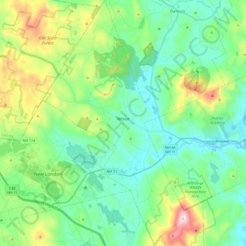
Name: Topografische Karte Wilmot, Höhe, Relief.
Ort: Wilmot, Merrimack County, New Hampshire, United States (43.36446 -71.99031 43.53353 -71.85623)
Durchschnittliche Höhe: 364 m
Minimale Höhe: 180 m
Maximale Höhe: 885 m
Mount Kearsarge, elevation 2,931 feet (893 m) above sea level, on the southern border, is the highest point in town and in Merrimack County. Winslow State Park, at the northern foot of the mountain, provides access by two hiking trails to the summit. The state park and the Winslow Trail are named after Captain John Winslow, the commander of the USS Kearsarge, which in June 1864 sank the CSS Alabama in the English Channel in a famous Civil War sea battle.
Andere topografische Karten
Klicken Sie auf eine Karte, um ihre Topografie, ihre Höhe und ihr Relief anzuzeigen.
New London
United States > New Hampshire > Merrimack County
New London, Merrimack County, New Hampshire, United States
Durchschnittliche Höhe: 365 m
Suncook
United States > New Hampshire > Merrimack County > Pembroke
Suncook, Pembroke, Merrimack County, New Hampshire, 03275, United States
Durchschnittliche Höhe: 93 m
Bow
United States > New Hampshire > Merrimack County
Bow, Merrimack County, New Hampshire, 03304, United States
Durchschnittliche Höhe: 152 m
Warner
United States > New Hampshire > Merrimack County
Warner, Merrimack County, New Hampshire, United States
Durchschnittliche Höhe: 247 m
Henniker
United States > New Hampshire > Merrimack County
Henniker, Merrimack County, New Hampshire, 03242, United States
Durchschnittliche Höhe: 223 m
Dunbarton
United States > New Hampshire > Merrimack County
Dunbarton, Merrimack County, New Hampshire, 03046, United States
Durchschnittliche Höhe: 167 m
Riverhill
United States > New Hampshire > Merrimack County > Concord
Riverhill, Concord, Merrimack County, New Hampshire, 03303, United States
Durchschnittliche Höhe: 140 m
Andover
United States > New Hampshire > Merrimack County > Andover
Andover, Merrimack County, New Hampshire, United States
Durchschnittliche Höhe: 301 m
Hooksett
United States > New Hampshire > Merrimack County
Hooksett, Merrimack County, New Hampshire, 03106, United States
Durchschnittliche Höhe: 130 m
Pembroke
United States > New Hampshire > Merrimack County
Pembroke, Merrimack County, New Hampshire, 03275, United States
Durchschnittliche Höhe: 131 m
Rings Corner
United States > New Hampshire > Merrimack County > Pittsfield > Rings Corner
Rings Corner, Pittsfield, Merrimack County, New Hampshire, 03274, United States
Durchschnittliche Höhe: 190 m
Hopkinton
United States > New Hampshire > Merrimack County
Hopkinton, Merrimack County, New Hampshire, 03229, United States
Durchschnittliche Höhe: 146 m
Pittsfield
United States > New Hampshire > Merrimack County
Pittsfield, Merrimack County, New Hampshire, 03263, United States
Durchschnittliche Höhe: 201 m
Loudon
United States > New Hampshire > Merrimack County
Loudon, Merrimack County, New Hampshire, United States
Durchschnittliche Höhe: 190 m
Concord
United States > New Hampshire > Merrimack County
Concord, Merrimack County, New Hampshire, United States
Durchschnittliche Höhe: 131 m