
Topografische Karte Hopkinton
Interaktive Karte
Klicken Sie auf die Karte, um die Höhe anzuzeigen.
Über diese Karte
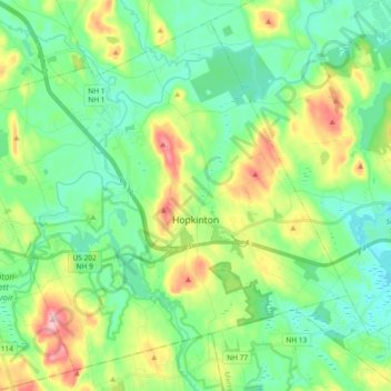
Name: Topografische Karte Hopkinton, Höhe, Relief.
Durchschnittliche Höhe: 146 m
Minimale Höhe: 90 m
Maximale Höhe: 281 m
According to the United States Census Bureau, the town has a total area of 45.1 square miles (116.8 km2), of which 43.3 square miles (112.1 km2) are land and 1.8 square miles (4.6 km2) are water, comprising 3.97% of the town. Hopkinton is drained by the Contoocook River and its tributary, the Warner River, except for the southeast part of town, which drains to the Turkey River. The highest point in town is Shaker Hill, on the border with Henniker, with an elevation of 923 feet (281 m) above sea level. Hopkinton lies fully within the Merrimack River watershed.
Andere topografische Karten
Klicken Sie auf eine Karte, um ihre Topografie, ihre Höhe und ihr Relief anzuzeigen.
Wilmot
United States > New Hampshire > Merrimack County
Wilmot, Merrimack County, New Hampshire, United States
Durchschnittliche Höhe: 364 m
New London
United States > New Hampshire > Merrimack County
New London, Merrimack County, New Hampshire, United States
Durchschnittliche Höhe: 365 m
Suncook
United States > New Hampshire > Merrimack County > Pembroke
Suncook, Pembroke, Merrimack County, New Hampshire, 03275, United States
Durchschnittliche Höhe: 93 m
Bow
United States > New Hampshire > Merrimack County
Bow, Merrimack County, New Hampshire, 03304, United States
Durchschnittliche Höhe: 152 m
Warner
United States > New Hampshire > Merrimack County
Warner, Merrimack County, New Hampshire, United States
Durchschnittliche Höhe: 247 m
Henniker
United States > New Hampshire > Merrimack County
Henniker, Merrimack County, New Hampshire, 03242, United States
Durchschnittliche Höhe: 223 m
Dunbarton
United States > New Hampshire > Merrimack County
Dunbarton, Merrimack County, New Hampshire, 03046, United States
Durchschnittliche Höhe: 167 m
Riverhill
United States > New Hampshire > Merrimack County > Concord
Riverhill, Concord, Merrimack County, New Hampshire, 03303, United States
Durchschnittliche Höhe: 140 m
Andover
United States > New Hampshire > Merrimack County > Andover
Andover, Merrimack County, New Hampshire, United States
Durchschnittliche Höhe: 301 m
Hooksett
United States > New Hampshire > Merrimack County
Hooksett, Merrimack County, New Hampshire, 03106, United States
Durchschnittliche Höhe: 130 m
Pembroke
United States > New Hampshire > Merrimack County
Pembroke, Merrimack County, New Hampshire, 03275, United States
Durchschnittliche Höhe: 131 m
Rings Corner
United States > New Hampshire > Merrimack County > Pittsfield > Rings Corner
Rings Corner, Pittsfield, Merrimack County, New Hampshire, 03274, United States
Durchschnittliche Höhe: 190 m
Pittsfield
United States > New Hampshire > Merrimack County
Pittsfield, Merrimack County, New Hampshire, 03263, United States
Durchschnittliche Höhe: 201 m
Loudon
United States > New Hampshire > Merrimack County
Loudon, Merrimack County, New Hampshire, United States
Durchschnittliche Höhe: 190 m
Concord
United States > New Hampshire > Merrimack County
Concord, Merrimack County, New Hampshire, United States
Durchschnittliche Höhe: 131 m