
Topografische Karte Sinaia
Interaktive Karte
Klicken Sie auf die Karte, um die Höhe anzuzeigen.
Über diese Karte
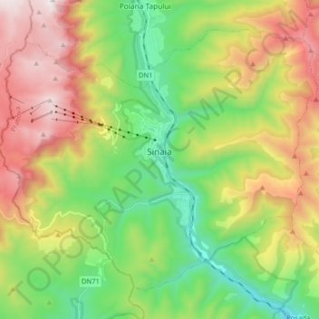
Name: Topografische Karte Sinaia, Höhe, Relief.
Ort: Sinaia, Prahova, 106100, Romania (45.29640 25.46770 45.38861 25.62769)
Durchschnittliche Höhe: 1’249 m
Minimale Höhe: 649 m
Maximale Höhe: 2’141 m
Sinaia is about 65 kilometres (40 miles) northwest of Ploiești and 48 kilometres (30 miles) south of Brașov, in a mountainous area on the Prahova River valley, just east of the Bucegi Mountains. The town's altitude varies between 767 to 860 metres (2,516 to 2,822 feet) above sea level.
Andere topografische Karten
Klicken Sie auf eine Karte, um ihre Topografie, ihre Höhe und ihr Relief anzuzeigen.
Vălenii de Munte
Vălenii de Munte, Prahova, 106400, Romania
Durchschnittliche Höhe: 416 m
Valea Călugărească
Romania > Prahova > Valea Călugărească
Valea Călugărească, Prahova, Romania
Durchschnittliche Höhe: 154 m
Chiojdeanca
Romania > Prahova > Chiojdeanca
Chiojdeanca, Prahova, 107150, Romania
Durchschnittliche Höhe: 321 m
Cornu de Jos
Cornu de Jos, Cornu, Prahova, 107180, Romania
Durchschnittliche Höhe: 488 m
Iordăcheanu
Romania > Prahova > Iordăcheanu
Iordăcheanu, Prahova, 107310, Romania
Durchschnittliche Höhe: 194 m