
Topografische Karte Bușteni
Interaktive Karte
Klicken Sie auf die Karte, um die Höhe anzuzeigen.
Über diese Karte
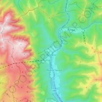
Name: Topografische Karte Bușteni, Höhe, Relief.
Ort: Bușteni, Prahova, Romania (45.36783 25.45256 45.47040 25.62365)
Durchschnittliche Höhe: 1’419 m
Minimale Höhe: 807 m
Maximale Höhe: 2’500 m
Bușteni (Romanian pronunciation: [buʃˈtenʲ]) is a small mountain town in the north of Prahova County, Muntenia, Romania. It is located in the Prahova Valley, at the bottom of the Bucegi Mountains, that have a maximum altitude of 2,505 m (8,219 ft). Its name literally means tree-logs in Romanian. One village, Poiana Țapului, is administratively part of the town, formerly a separate commune prior to 1950. According to the 2021 census, it has 8,368 inhabitants.
Andere topografische Karten
Klicken Sie auf eine Karte, um ihre Topografie, ihre Höhe und ihr Relief anzuzeigen.
Vălenii de Munte
Vălenii de Munte, Prahova, 106400, Romania
Durchschnittliche Höhe: 416 m
Valea Călugărească
Romania > Prahova > Valea Călugărească
Valea Călugărească, Prahova, Romania
Durchschnittliche Höhe: 154 m
Chiojdeanca
Romania > Prahova > Chiojdeanca
Chiojdeanca, Prahova, 107150, Romania
Durchschnittliche Höhe: 321 m
Cornu de Jos
Cornu de Jos, Cornu, Prahova, 107180, Romania
Durchschnittliche Höhe: 488 m
Iordăcheanu
Romania > Prahova > Iordăcheanu
Iordăcheanu, Prahova, 107310, Romania
Durchschnittliche Höhe: 194 m