
Topografische Karte Ploiești
Interaktive Karte
Klicken Sie auf die Karte, um die Höhe anzuzeigen.
Über diese Karte
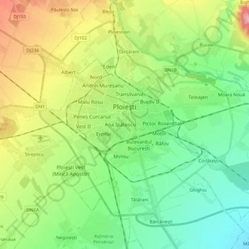
Name: Topografische Karte Ploiești, Höhe, Relief.
Ort: Ploiești, Prahova, Romania (44.89614 25.91790 44.96842 26.10197)
Durchschnittliche Höhe: 158 m
Minimale Höhe: 105 m
Maximale Höhe: 264 m
The city lies on the Wallachian Plain, having an average altitude of 150 m (490 ft). The surrounding landscape is influenced by its position around the Prahova River, whose stream bed lies 25 km (16 mi) to the west. The Teleajen River passes through the city while the Dâmbu River passes through the north-eastern neighbourhoods.
Andere topografische Karten
Klicken Sie auf eine Karte, um ihre Topografie, ihre Höhe und ihr Relief anzuzeigen.
Vălenii de Munte
Vălenii de Munte, Prahova, 106400, Romania
Durchschnittliche Höhe: 416 m
Valea Călugărească
Romania > Prahova > Valea Călugărească
Valea Călugărească, Prahova, Romania
Durchschnittliche Höhe: 154 m
Chiojdeanca
Romania > Prahova > Chiojdeanca
Chiojdeanca, Prahova, 107150, Romania
Durchschnittliche Höhe: 321 m
Cornu de Jos
Cornu de Jos, Cornu, Prahova, 107180, Romania
Durchschnittliche Höhe: 488 m
Iordăcheanu
Romania > Prahova > Iordăcheanu
Iordăcheanu, Prahova, 107310, Romania
Durchschnittliche Höhe: 194 m