
Spenden
Rüste dich für dein nächstes Abenteuer:
Als Amazon-Partner verdient diese Seite an qualifizierten Käufen, ohne dass Ihnen zusätzliche Kosten entstehen.
Topografische Karte Wolf Island
Klicken Sie auf die Karte, um die Höhe anzuzeigen.
Spenden
Rüste dich für dein nächstes Abenteuer:
Als Amazon-Partner verdient diese Seite an qualifizierten Käufen, ohne dass Ihnen zusätzliche Kosten entstehen.
Über diese Karte
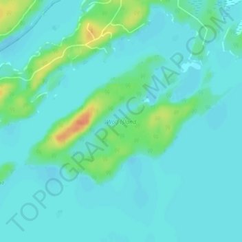
Name: Topografische Karte Wolf Island, Höhe, Relief.
Durchschnittliche Höhe: 327 m
Minimale Höhe: 318 m
Maximale Höhe: 359 m
Spenden
Rüste dich für dein nächstes Abenteuer:
Als Amazon-Partner verdient diese Seite an qualifizierten Käufen, ohne dass Ihnen zusätzliche Kosten entstehen.
Andere topografische Karten
Klicken Sie auf eine Karte, um ihre Topografie, ihre Höhe und ihr Relief anzuzeigen.
Kushog Lake
Canada > Ontario > Kenora District > Unorganized Kenora District
Durchschnittliche Höhe: 405 m
MacDowell Lake
Canada > Ontario > Kenora District > Unorganized Kenora District
Durchschnittliche Höhe: 386 m
Rowdy Lake
Canada > Ontario > Kenora District > Unorganized Kenora District
Durchschnittliche Höhe: 370 m
Lake Charles
Canada > Ontario > Kenora District > Unorganized Kenora District
Durchschnittliche Höhe: 346 m
Spenden
Rüste dich für dein nächstes Abenteuer:
Als Amazon-Partner verdient diese Seite an qualifizierten Käufen, ohne dass Ihnen zusätzliche Kosten entstehen.
Fiddler Lake
Canada > Ontario > Kenora District > Unorganized Kenora District
Durchschnittliche Höhe: 293 m
Wabigoon
Canada > Ontario > Kenora District > Unorganized Kenora District
Durchschnittliche Höhe: 381 m
Big Canon Lake
Canada > Ontario > Kenora District > Unorganized Kenora District
Durchschnittliche Höhe: 363 m
Spenden
Rüste dich für dein nächstes Abenteuer:
Als Amazon-Partner verdient diese Seite an qualifizierten Käufen, ohne dass Ihnen zusätzliche Kosten entstehen.
Star Lake
Canada > Ontario > Kenora District > Unorganized Kenora District
Durchschnittliche Höhe: 382 m
Hudson Bay Lowlands
Canada > Ontario > Kenora District > Unorganized Kenora District
Durchschnittliche Höhe: 17 m
Dinorwic
Canada > Ontario > Kenora District > Unorganized Kenora District
Durchschnittliche Höhe: 383 m
Minnitaki Lake
Canada > Ontario > Kenora District > Unorganized Kenora District
Durchschnittliche Höhe: 386 m
Spenden
Rüste dich für dein nächstes Abenteuer:
Als Amazon-Partner verdient diese Seite an qualifizierten Käufen, ohne dass Ihnen zusätzliche Kosten entstehen.
Dogtooth Lake
Canada > Ontario > Kenora District > Unorganized Kenora District
Durchschnittliche Höhe: 361 m
Artery Lake
Canada > Ontario > Kenora District > Unorganized Kenora District
Durchschnittliche Höhe: 334 m
Maynard Lake
Canada > Ontario > Kenora District > Unorganized Kenora District
Durchschnittliche Höhe: 337 m
Clearwater Bay
Canada > Ontario > Kenora District > Unorganized Kenora District
Durchschnittliche Höhe: 334 m
Spenden
Rüste dich für dein nächstes Abenteuer:
Als Amazon-Partner verdient diese Seite an qualifizierten Käufen, ohne dass Ihnen zusätzliche Kosten entstehen.
Canyon Lake
Canada > Ontario > Kenora District > Unorganized Kenora District
Durchschnittliche Höhe: 405 m
Axe Lake
Canada > Ontario > Kenora District > Unorganized Kenora District
Durchschnittliche Höhe: 369 m
Confederation Lake
Canada > Ontario > Kenora District > Unorganized Kenora District
Durchschnittliche Höhe: 414 m
Fredart Lake
Canada > Ontario > Kenora District > Unorganized Kenora District
Durchschnittliche Höhe: 409 m
Spenden
Rüste dich für dein nächstes Abenteuer:
Als Amazon-Partner verdient diese Seite an qualifizierten Käufen, ohne dass Ihnen zusätzliche Kosten entstehen.
Two Island Lake
Canada > Ontario > Kenora District > Unorganized Kenora District
Durchschnittliche Höhe: 361 m
Affleck Lake
Canada > Ontario > Kenora District > Unorganized Kenora District
Durchschnittliche Höhe: 421 m
Spadina Lake
Canada > Ontario > Kenora District > Unorganized Kenora District
Durchschnittliche Höhe: 376 m
lac Seul
Canada > Ontario > Kenora District > Unorganized Kenora District
Lac Seul is a large, crescent shaped reservoir in Kenora District, northwestern Ontario, Canada. It is approximately 241 km (150 mi) long. It has a maximum (regulated) depth of 47.2 m, with a surface elevation of 357 m above sea level. Its level is raised in the summer and then drawn down in the winter months…
Durchschnittliche Höhe: 374 m
Spenden
Rüste dich für dein nächstes Abenteuer:
Als Amazon-Partner verdient diese Seite an qualifizierten Käufen, ohne dass Ihnen zusätzliche Kosten entstehen.
Ena Lake
Canada > Ontario > Kenora District > Unorganized Kenora District
Durchschnittliche Höhe: 350 m
McIntosh Lake
Canada > Ontario > Kenora District > Unorganized Kenora District
Durchschnittliche Höhe: 395 m
Oxdrift
Canada > Ontario > Kenora District > Unorganized Kenora District
Durchschnittliche Höhe: 364 m
Gordon Island
Canada > Ontario > Kenora District > Unorganized Kenora District
Durchschnittliche Höhe: 349 m
Spenden
Rüste dich für dein nächstes Abenteuer:
Als Amazon-Partner verdient diese Seite an qualifizierten Käufen, ohne dass Ihnen zusätzliche Kosten entstehen.
Blackstone Lake
Canada > Ontario > Kenora District > Unorganized Kenora District
Durchschnittliche Höhe: 382 m
Bass Lake
Canada > Ontario > Kenora District > Unorganized Kenora District
Durchschnittliche Höhe: 387 m
Spenden
Rüste dich für dein nächstes Abenteuer:
Als Amazon-Partner verdient diese Seite an qualifizierten Käufen, ohne dass Ihnen zusätzliche Kosten entstehen.
Winnipeg River
Canada > Ontario > Kenora District > Unorganized Kenora District
Durchschnittliche Höhe: 317 m
Shoal Lake
Canada > Ontario > Kenora District > Unorganized Kenora District
Durchschnittliche Höhe: 325 m
Cygnet Lake
Canada > Ontario > Kenora District > Unorganized Kenora District
Durchschnittliche Höhe: 339 m
Spenden
Rüste dich für dein nächstes Abenteuer:
Als Amazon-Partner verdient diese Seite an qualifizierten Käufen, ohne dass Ihnen zusätzliche Kosten entstehen.
West Arm
Canada > Ontario > Kenora District > Unorganized Kenora District
Durchschnittliche Höhe: 379 m
Brock Lake
Canada > Ontario > Kenora District > Unorganized Kenora District
Durchschnittliche Höhe: 311 m
Spenden
Rüste dich für dein nächstes Abenteuer:
Als Amazon-Partner verdient diese Seite an qualifizierten Käufen, ohne dass Ihnen zusätzliche Kosten entstehen.
Mackey Island
Canada > Ontario > Kenora District > Unorganized Kenora District
Durchschnittliche Höhe: 336 m
Betula Lake
Canada > Ontario > Kenora District > Unorganized Kenora District
Durchschnittliche Höhe: 371 m
Lac Seul
Canada > Ontario > Kenora District > Unorganized Kenora District
Durchschnittliche Höhe: 371 m
Stormy Lake
Canada > Ontario > Kenora District > Unorganized Kenora District
Durchschnittliche Höhe: 414 m
Spenden
Rüste dich für dein nächstes Abenteuer:
Als Amazon-Partner verdient diese Seite an qualifizierten Käufen, ohne dass Ihnen zusätzliche Kosten entstehen.
Whitefish Lake
Canada > Ontario > Kenora District > Unorganized Kenora District
Durchschnittliche Höhe: 380 m
Slate Falls
Canada > Ontario > Kenora District > Unorganized Kenora District
Durchschnittliche Höhe: 385 m
Wabaskang Lake
Canada > Ontario > Kenora District > Unorganized Kenora District
Durchschnittliche Höhe: 375 m
Eagle Lake
Canada > Ontario > Kenora District > Unorganized Kenora District
Durchschnittliche Höhe: 379 m
Spenden
Rüste dich für dein nächstes Abenteuer:
Als Amazon-Partner verdient diese Seite an qualifizierten Käufen, ohne dass Ihnen zusätzliche Kosten entstehen.
Kukukus Lake
Canada > Ontario > Kenora District > Unorganized Kenora District
Durchschnittliche Höhe: 405 m
Minnitaki Lake
Canada > Ontario > Kenora District > Unorganized Kenora District
Durchschnittliche Höhe: 386 m
Thaddeus
Canada > Ontario > Kenora District > Unorganized Kenora District
Durchschnittliche Höhe: 411 m
Cluster Lakes
Canada > Ontario > Kenora District > Unorganized Kenora District
Durchschnittliche Höhe: 443 m
Spenden
Rüste dich für dein nächstes Abenteuer:
Als Amazon-Partner verdient diese Seite an qualifizierten Käufen, ohne dass Ihnen zusätzliche Kosten entstehen.
Antenna Lake
Canada > Ontario > Kenora District > Unorganized Kenora District
Durchschnittliche Höhe: 393 m
Swan Lake
Canada > Ontario > Kenora District > Unorganized Kenora District
Durchschnittliche Höhe: 323 m
Cameron Island
Canada > Ontario > Kenora District > Unorganized Kenora District
Durchschnittliche Höhe: 338 m
Spenden
Rüste dich für dein nächstes Abenteuer:
Als Amazon-Partner verdient diese Seite an qualifizierten Käufen, ohne dass Ihnen zusätzliche Kosten entstehen.