
Spenden
Rüste dich für dein nächstes Abenteuer:
Als Amazon-Partner verdient diese Seite an qualifizierten Käufen, ohne dass Ihnen zusätzliche Kosten entstehen.
Topografische Karte Whitefish Lake
Klicken Sie auf die Karte, um die Höhe anzuzeigen.
Spenden
Rüste dich für dein nächstes Abenteuer:
Als Amazon-Partner verdient diese Seite an qualifizierten Käufen, ohne dass Ihnen zusätzliche Kosten entstehen.
Über diese Karte
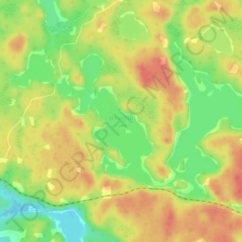
Name: Topografische Karte Whitefish Lake, Höhe, Relief.
Durchschnittliche Höhe: 380 m
Minimale Höhe: 348 m
Maximale Höhe: 404 m
Spenden
Rüste dich für dein nächstes Abenteuer:
Als Amazon-Partner verdient diese Seite an qualifizierten Käufen, ohne dass Ihnen zusätzliche Kosten entstehen.
Andere topografische Karten
Klicken Sie auf eine Karte, um ihre Topografie, ihre Höhe und ihr Relief anzuzeigen.
Carroll Lake
Canada > Ontario > Kenora District > Unorganized Kenora District
Durchschnittliche Höhe: 338 m
Wolf Island
Canada > Ontario > Kenora District > Unorganized Kenora District
Durchschnittliche Höhe: 327 m
Burditt Lake
Canada > Ontario > Kenora District > Unorganized Kenora District
Durchschnittliche Höhe: 367 m
Spenden
Rüste dich für dein nächstes Abenteuer:
Als Amazon-Partner verdient diese Seite an qualifizierten Käufen, ohne dass Ihnen zusätzliche Kosten entstehen.
Wabigoon
Canada > Ontario > Kenora District > Unorganized Kenora District
Durchschnittliche Höhe: 381 m
Cardinal (Lac) Lake
Canada > Ontario > Kenora District > Unorganized Kenora District
Durchschnittliche Höhe: 392 m
Hudson Bay Lowlands
Canada > Ontario > Kenora District > Unorganized Kenora District
Durchschnittliche Höhe: 17 m
Dinorwic
Canada > Ontario > Kenora District > Unorganized Kenora District
Durchschnittliche Höhe: 383 m
Spenden
Rüste dich für dein nächstes Abenteuer:
Als Amazon-Partner verdient diese Seite an qualifizierten Käufen, ohne dass Ihnen zusätzliche Kosten entstehen.
Clearwater Bay
Canada > Ontario > Kenora District > Unorganized Kenora District
Durchschnittliche Höhe: 334 m
Canyon Lake
Canada > Ontario > Kenora District > Unorganized Kenora District
Durchschnittliche Höhe: 405 m
Ena Lake
Canada > Ontario > Kenora District > Unorganized Kenora District
Durchschnittliche Höhe: 350 m
Granite Lake
Canada > Ontario > Kenora District > Unorganized Kenora District
Durchschnittliche Höhe: 355 m
Spenden
Rüste dich für dein nächstes Abenteuer:
Als Amazon-Partner verdient diese Seite an qualifizierten Käufen, ohne dass Ihnen zusätzliche Kosten entstehen.
Oxdrift
Canada > Ontario > Kenora District > Unorganized Kenora District
Durchschnittliche Höhe: 364 m
Gordon Island
Canada > Ontario > Kenora District > Unorganized Kenora District
Durchschnittliche Höhe: 349 m
Spenden
Rüste dich für dein nächstes Abenteuer:
Als Amazon-Partner verdient diese Seite an qualifizierten Käufen, ohne dass Ihnen zusätzliche Kosten entstehen.
Twin Lake
Canada > Ontario > Kenora District > Unorganized Kenora District
Durchschnittliche Höhe: 399 m
Clear Lake
Canada > Ontario > Kenora District > Unorganized Kenora District
Durchschnittliche Höhe: 367 m
Shoal Lake
Canada > Ontario > Kenora District > Unorganized Kenora District
Durchschnittliche Höhe: 325 m
Grindstone Lake
Canada > Ontario > Kenora District > Unorganized Kenora District
Durchschnittliche Höhe: 371 m
Spenden
Rüste dich für dein nächstes Abenteuer:
Als Amazon-Partner verdient diese Seite an qualifizierten Käufen, ohne dass Ihnen zusätzliche Kosten entstehen.
Look Lake
Canada > Ontario > Kenora District > Unorganized Kenora District
Durchschnittliche Höhe: 393 m
Warwick Lake
Canada > Ontario > Kenora District > Unorganized Kenora District
Durchschnittliche Höhe: 341 m
West Arm
Canada > Ontario > Kenora District > Unorganized Kenora District
Durchschnittliche Höhe: 379 m
Spenden
Rüste dich für dein nächstes Abenteuer:
Als Amazon-Partner verdient diese Seite an qualifizierten Käufen, ohne dass Ihnen zusätzliche Kosten entstehen.
Slate Islands
Canada > Ontario > Kenora District > Unorganized Kenora District
Durchschnittliche Höhe: 322 m
Mackey Island
Canada > Ontario > Kenora District > Unorganized Kenora District
Durchschnittliche Höhe: 336 m
Spenden
Rüste dich für dein nächstes Abenteuer:
Als Amazon-Partner verdient diese Seite an qualifizierten Käufen, ohne dass Ihnen zusätzliche Kosten entstehen.
Big Island Lake
Canada > Ontario > Kenora District > Unorganized Kenora District
Durchschnittliche Höhe: 430 m
Nine Mile Lake
Canada > Ontario > Kenora District > Unorganized Kenora District
Durchschnittliche Höhe: 413 m
Arpin Lake
Canada > Ontario > Kenora District > Unorganized Kenora District
Durchschnittliche Höhe: 383 m
Mills Lake
Canada > Ontario > Kenora District > Unorganized Kenora District
Durchschnittliche Höhe: 380 m
Spenden
Rüste dich für dein nächstes Abenteuer:
Als Amazon-Partner verdient diese Seite an qualifizierten Käufen, ohne dass Ihnen zusätzliche Kosten entstehen.
Betula Lake
Canada > Ontario > Kenora District > Unorganized Kenora District
Durchschnittliche Höhe: 371 m
Beauty Lake
Canada > Ontario > Kenora District > Unorganized Kenora District
Durchschnittliche Höhe: 348 m
Chisholm Island
Canada > Ontario > Kenora District > Unorganized Kenora District
Durchschnittliche Höhe: 323 m
Boyne Lake
Canada > Ontario > Kenora District > Unorganized Kenora District
Durchschnittliche Höhe: 361 m
Spenden
Rüste dich für dein nächstes Abenteuer:
Als Amazon-Partner verdient diese Seite an qualifizierten Käufen, ohne dass Ihnen zusätzliche Kosten entstehen.
Muskeg River
Canada > Ontario > Kenora District > Unorganized Kenora District
Durchschnittliche Höhe: 357 m
Slate Falls
Canada > Ontario > Kenora District > Unorganized Kenora District
Durchschnittliche Höhe: 385 m
Muskeg River
Canada > Ontario > Kenora District > Unorganized Kenora District
Durchschnittliche Höhe: 363 m
Dingwall Island
Canada > Ontario > Kenora District > Unorganized Kenora District
Durchschnittliche Höhe: 325 m
Spenden
Rüste dich für dein nächstes Abenteuer:
Als Amazon-Partner verdient diese Seite an qualifizierten Käufen, ohne dass Ihnen zusätzliche Kosten entstehen.
Thaddeus
Canada > Ontario > Kenora District > Unorganized Kenora District
Durchschnittliche Höhe: 411 m
Little Boulder Lake
Canada > Ontario > Kenora District > Unorganized Kenora District
Durchschnittliche Höhe: 359 m
Cameron Island
Canada > Ontario > Kenora District > Unorganized Kenora District
Durchschnittliche Höhe: 338 m
Spenden
Rüste dich für dein nächstes Abenteuer:
Als Amazon-Partner verdient diese Seite an qualifizierten Käufen, ohne dass Ihnen zusätzliche Kosten entstehen.