
Topografische Karte McIntosh Lake
Klicken Sie auf die Karte, um die Höhe anzuzeigen.
Über diese Karte
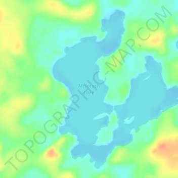
Name: Topografische Karte McIntosh Lake, Höhe, Relief.
Durchschnittliche Höhe: 395 m
Minimale Höhe: 381 m
Maximale Höhe: 422 m
Andere topografische Karten
Klicken Sie auf eine Karte, um ihre Topografie, ihre Höhe und ihr Relief anzuzeigen.
Burditt Lake
Canada > Ontario > Kenora District > Unorganized Kenora District
Durchschnittliche Höhe: 367 m
Shoal Lake
Canada > Ontario > Kenora District > Unorganized Kenora District
Durchschnittliche Höhe: 325 m
Carroll Lake
Canada > Ontario > Kenora District > Unorganized Kenora District
Durchschnittliche Höhe: 338 m
Boyne Lake
Canada > Ontario > Kenora District > Unorganized Kenora District
Durchschnittliche Höhe: 361 m
Granite Lake
Canada > Ontario > Kenora District > Unorganized Kenora District
Durchschnittliche Höhe: 355 m
Wolf Island
Canada > Ontario > Kenora District > Unorganized Kenora District
Durchschnittliche Höhe: 327 m
Wabigoon
Canada > Ontario > Kenora District > Unorganized Kenora District
Durchschnittliche Höhe: 381 m
Cardinal (Lac) Lake
Canada > Ontario > Kenora District > Unorganized Kenora District
Durchschnittliche Höhe: 392 m
Hudson Bay Lowlands
Canada > Ontario > Kenora District > Unorganized Kenora District
Durchschnittliche Höhe: 17 m
Dinorwic
Canada > Ontario > Kenora District > Unorganized Kenora District
Durchschnittliche Höhe: 383 m
Big Island Lake
Canada > Ontario > Kenora District > Unorganized Kenora District
Durchschnittliche Höhe: 430 m
Arpin Lake
Canada > Ontario > Kenora District > Unorganized Kenora District
Durchschnittliche Höhe: 383 m
Mills Lake
Canada > Ontario > Kenora District > Unorganized Kenora District
Durchschnittliche Höhe: 380 m
Betula Lake
Canada > Ontario > Kenora District > Unorganized Kenora District
Durchschnittliche Höhe: 371 m
Beauty Lake
Canada > Ontario > Kenora District > Unorganized Kenora District
Durchschnittliche Höhe: 348 m
Clearwater Bay
Canada > Ontario > Kenora District > Unorganized Kenora District
Durchschnittliche Höhe: 334 m
Slate Falls
Canada > Ontario > Kenora District > Unorganized Kenora District
Durchschnittliche Höhe: 385 m
Wabauskang 21
Canada > Ontario > Kenora District > Unorganized Kenora District
Durchschnittliche Höhe: 368 m
Canyon Lake
Canada > Ontario > Kenora District > Unorganized Kenora District
Durchschnittliche Höhe: 405 m
Dingwall Island
Canada > Ontario > Kenora District > Unorganized Kenora District
Durchschnittliche Höhe: 325 m
Ena Lake
Canada > Ontario > Kenora District > Unorganized Kenora District
Durchschnittliche Höhe: 350 m
Oxdrift
Canada > Ontario > Kenora District > Unorganized Kenora District
Durchschnittliche Höhe: 364 m
Gordon Island
Canada > Ontario > Kenora District > Unorganized Kenora District
Durchschnittliche Höhe: 349 m
Twin Lake
Canada > Ontario > Kenora District > Unorganized Kenora District
Durchschnittliche Höhe: 399 m
Clear Lake
Canada > Ontario > Kenora District > Unorganized Kenora District
Durchschnittliche Höhe: 367 m
Grindstone Lake
Canada > Ontario > Kenora District > Unorganized Kenora District
Durchschnittliche Höhe: 371 m
Look Lake
Canada > Ontario > Kenora District > Unorganized Kenora District
Durchschnittliche Höhe: 393 m
Warwick Lake
Canada > Ontario > Kenora District > Unorganized Kenora District
Durchschnittliche Höhe: 341 m
West Arm
Canada > Ontario > Kenora District > Unorganized Kenora District
Durchschnittliche Höhe: 379 m
Slate Islands
Canada > Ontario > Kenora District > Unorganized Kenora District
Durchschnittliche Höhe: 322 m
Nine Mile Lake
Canada > Ontario > Kenora District > Unorganized Kenora District
Durchschnittliche Höhe: 413 m
Chisholm Island
Canada > Ontario > Kenora District > Unorganized Kenora District
Durchschnittliche Höhe: 323 m
Muskeg River
Canada > Ontario > Kenora District > Unorganized Kenora District
Durchschnittliche Höhe: 357 m
Mackey Island
Canada > Ontario > Kenora District > Unorganized Kenora District
Durchschnittliche Höhe: 336 m
Muskeg River
Canada > Ontario > Kenora District > Unorganized Kenora District
Durchschnittliche Höhe: 363 m
Tablerock Lake
Canada > Ontario > Kenora District > Unorganized Kenora District
Durchschnittliche Höhe: 384 m
Thaddeus
Canada > Ontario > Kenora District > Unorganized Kenora District
Durchschnittliche Höhe: 411 m
Little Boulder Lake
Canada > Ontario > Kenora District > Unorganized Kenora District
Durchschnittliche Höhe: 359 m
Cameron Island
Canada > Ontario > Kenora District > Unorganized Kenora District
Durchschnittliche Höhe: 338 m