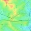
Topografische Karte Smithfield
Klicken Sie auf die Karte, um die Höhe anzuzeigen.
Smithfield
Smithfield is within the plant community called the Cumberland Plain Woodland and contains a small patch of the threatened Cooks River/Castlereagh Ironbark Forest (within Smithfield Cemetery), which feature Eucalyptus fibrosa, Melaleuca decora and Eucalyptus moluccana as the dominant canopy species. Somewhat hilly, Smithfield's altitude ranges from 20 to 55 m (66 to 180 ft) above sea level, with its highest elevations around Brenan Park, along its western boundary with Wetherill Park at Wetherill Street, and along its northeastern boundary with Woodpark and Greystanes. The lowest-lying areas are in the central and southeastern parts of the suburb. The suburb is situated on the Cumberland Plain biogeographic region and it predominantly lies on the Middle Triassic Bringelly Shale (with the areas near Prospect Creek being on Cenozoic alluvial deposits).
Über diese Karte
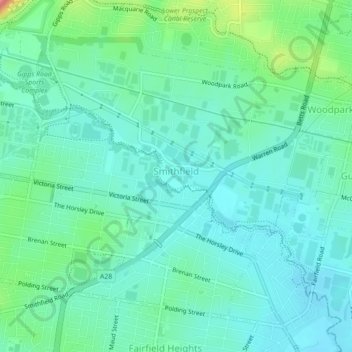
Name: Topografische Karte Smithfield, Höhe, Relief.
Ort: Smithfield, Sydney, New South Wales, 2164, Australia (-33.86313 150.91634 -33.83357 150.96051)
Durchschnittliche Höhe: 33 m
Minimale Höhe: 10 m
Maximale Höhe: 111 m
Andere topografische Karten
Klicken Sie auf eine Karte, um ihre Topografie, ihre Höhe und ihr Relief anzuzeigen.



















Bents Basin State Conservation Area
Australia > New South Wales > Sydney
The park is popular for swimming, kayaking, bushwalking, camping (with 100 tent sites), barbecuing, picnicking and fishing. The park also features walking trails within a bushland and an education centre with a commercial kitchen. Caley's Lookout Track, a walking track within the bushland, leads to Little…
Durchschnittliche Höhe: 82 m