Topografische Karte Morriston
Interaktive Karte
Klicken Sie auf die Karte, um die Höhe anzuzeigen.
Über diese Karte
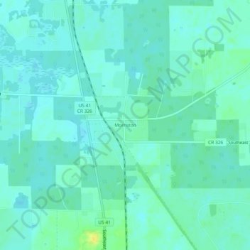
Name: Topografische Karte Morriston, Höhe, Relief.
Ort: Morriston, Levy County, Florida, United States (29.26164 -82.45788 29.30164 -82.41788)
Durchschnittliche Höhe: 20 m
Minimale Höhe: 15 m
Maximale Höhe: 36 m
Andere topografische Karten
Klicken Sie auf eine Karte, um ihre Topografie, ihre Höhe und ihr Relief anzuzeigen.
Cedar Key
United States > Florida > Levy County
Cedar Key, Levy County, Florida, United States
Durchschnittliche Höhe: 2 m
Goethe State Forest
United States > Florida > Levy County > Newberry
Goethe State Forest, Newberry, Levy County, Florida, United States
Durchschnittliche Höhe: 17 m
Otter Creek
United States > Florida > Levy County
Otter Creek, Levy County, Florida, 32683, United States
Durchschnittliche Höhe: 8 m
Williston
United States > Florida > Levy County
Williston, Levy County, Florida, United States
Durchschnittliche Höhe: 23 m
Yankeetown
United States > Florida > Levy County > Yankeetown
Yankeetown, Levy County, Florida, 34498, United States
Durchschnittliche Höhe: 6 m
Inglis
United States > Florida > Levy County
Inglis, Levy County, Florida, United States
Durchschnittliche Höhe: 10 m
Bronson
United States > Florida > Levy County
Bronson, Levy County, Florida, United States
Durchschnittliche Höhe: 21 m
Fanning Springs
United States > Florida > Levy County
Fanning Springs, Levy County, Florida, United States
Durchschnittliche Höhe: 9 m