
Spenden
Rüste dich für dein nächstes Abenteuer:
Als Amazon-Partner verdient diese Seite an qualifizierten Käufen, ohne dass Ihnen zusätzliche Kosten entstehen.
Topografische Karte Daly Hill
Klicken Sie auf die Karte, um die Höhe anzuzeigen.
Spenden
Rüste dich für dein nächstes Abenteuer:
Als Amazon-Partner verdient diese Seite an qualifizierten Käufen, ohne dass Ihnen zusätzliche Kosten entstehen.
Über diese Karte
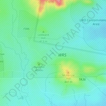
Name: Topografische Karte Daly Hill, Höhe, Relief.
Ort: Daly Hill, Comanche County, Oklahoma, United States (34.65859 -98.48996 34.65899 -98.48926)
Durchschnittliche Höhe: 396 m
Minimale Höhe: 371 m
Maximale Höhe: 480 m
Spenden
Rüste dich für dein nächstes Abenteuer:
Als Amazon-Partner verdient diese Seite an qualifizierten Käufen, ohne dass Ihnen zusätzliche Kosten entstehen.
Andere topografische Karten
Klicken Sie auf eine Karte, um ihre Topografie, ihre Höhe und ihr Relief anzuzeigen.
Lawton
United States > Oklahoma > Comanche County
Developed on former reservation lands of the Kiowa, Comanche, and Apache Indians, Lawton was founded by European Americans on 6 August 1901. It was named after Major General Henry Ware Lawton, who served in the Civil War, where he earned the Medal of Honor, and was killed in action in the Philippine–American…
Durchschnittliche Höhe: 352 m
Spenden
Rüste dich für dein nächstes Abenteuer:
Als Amazon-Partner verdient diese Seite an qualifizierten Käufen, ohne dass Ihnen zusätzliche Kosten entstehen.
Wichita Mountains Wildlife Refuge
United States > Oklahoma > Comanche County
Durchschnittliche Höhe: 592 m
Wichita Mountains National Wildlife Refuge
United States > Oklahoma > Comanche County > Medicine Park
Durchschnittliche Höhe: 498 m
Spenden
Rüste dich für dein nächstes Abenteuer:
Als Amazon-Partner verdient diese Seite an qualifizierten Käufen, ohne dass Ihnen zusätzliche Kosten entstehen.
Lawton
United States > Oklahoma > Comanche County
Developed on former reservation lands of the Kiowa, Comanche, and Apache peoples, Lawton was incorporated in 1901. It was named after Major General Henry Ware Lawton, who served in the Civil War, where he earned the Medal of Honor, and was killed in action in the Philippine–American War. Lawton's landscape…
Durchschnittliche Höhe: 352 m
South East Corner Landing Strip
United States > Oklahoma > Comanche County
Durchschnittliche Höhe: 383 m
Spenden
Rüste dich für dein nächstes Abenteuer:
Als Amazon-Partner verdient diese Seite an qualifizierten Käufen, ohne dass Ihnen zusätzliche Kosten entstehen.
Medicine Park
United States > Oklahoma > Comanche County > Medicine Park
Durchschnittliche Höhe: 429 m