
Spenden
Rüste dich für dein nächstes Abenteuer:
Als Amazon-Partner verdient diese Seite an qualifizierten Käufen, ohne dass Ihnen zusätzliche Kosten entstehen.
Topografische Karte Fort Sill
Klicken Sie auf die Karte, um die Höhe anzuzeigen.
Spenden
Rüste dich für dein nächstes Abenteuer:
Als Amazon-Partner verdient diese Seite an qualifizierten Käufen, ohne dass Ihnen zusätzliche Kosten entstehen.
Über diese Karte
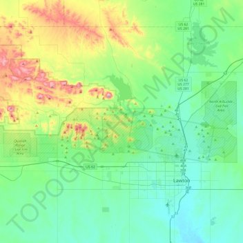
Name: Topografische Karte Fort Sill, Höhe, Relief.
Ort: Fort Sill, Comanche County, Oklahoma, United States (34.63753 -98.75591 34.76803 -98.28239)
Durchschnittliche Höhe: 417 m
Minimale Höhe: 314 m
Maximale Höhe: 749 m
Spenden
Rüste dich für dein nächstes Abenteuer:
Als Amazon-Partner verdient diese Seite an qualifizierten Käufen, ohne dass Ihnen zusätzliche Kosten entstehen.
Andere topografische Karten
Klicken Sie auf eine Karte, um ihre Topografie, ihre Höhe und ihr Relief anzuzeigen.
Wichita Mountains Wildlife Refuge
United States > Oklahoma > Comanche County
Durchschnittliche Höhe: 592 m
Medicine Bluffs
United States > Oklahoma > Comanche County > Lawton > White Wolf Bridge
Durchschnittliche Höhe: 363 m
Spenden
Rüste dich für dein nächstes Abenteuer:
Als Amazon-Partner verdient diese Seite an qualifizierten Käufen, ohne dass Ihnen zusätzliche Kosten entstehen.
Spenden
Rüste dich für dein nächstes Abenteuer:
Als Amazon-Partner verdient diese Seite an qualifizierten Käufen, ohne dass Ihnen zusätzliche Kosten entstehen.
South East Corner Landing Strip
United States > Oklahoma > Comanche County
Durchschnittliche Höhe: 383 m