
Topografische Karte South East Corner Landing Strip
Interaktive Karte
Klicken Sie auf die Karte, um die Höhe anzuzeigen.
Über diese Karte
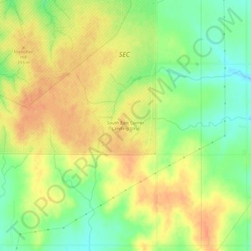
Name: Topografische Karte South East Corner Landing Strip, Höhe, Relief.
Durchschnittliche Höhe: 383 m
Minimale Höhe: 360 m
Maximale Höhe: 399 m
Andere topografische Karten
Klicken Sie auf eine Karte, um ihre Topografie, ihre Höhe und ihr Relief anzuzeigen.
Daly Hill
United States > Oklahoma > Comanche County
Daly Hill, Comanche County, Oklahoma, United States
Durchschnittliche Höhe: 396 m
Jackson Hole
United States > Oklahoma > Comanche County
Jackson Hole, Comanche County, Oklahoma, United States
Durchschnittliche Höhe: 406 m
Mount McKinley
United States > Oklahoma > Comanche County
Mount McKinley, Comanche County, Oklahoma, United States
Durchschnittliche Höhe: 498 m
Fort Sill
United States > Oklahoma > Comanche County
Fort Sill, Comanche County, Oklahoma, United States
Durchschnittliche Höhe: 417 m
Medicine Park
United States > Oklahoma > Comanche County > Medicine Park
Medicine Park, Comanche County, Oklahoma, 73557, United States
Durchschnittliche Höhe: 429 m
Lawton
United States > Oklahoma > Comanche County
Lawton, Comanche County, Oklahoma, United States
Durchschnittliche Höhe: 352 m