
Topografische Karte Seeley Lake
Interaktive Karte
Klicken Sie auf die Karte, um die Höhe anzuzeigen.
Über diese Karte
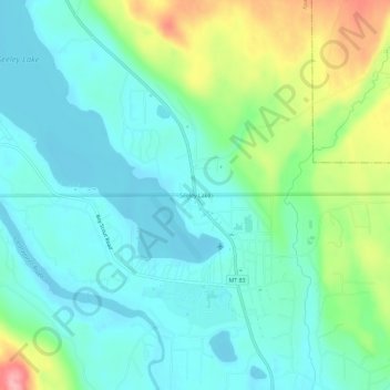
Name: Topografische Karte Seeley Lake, Höhe, Relief.
Durchschnittliche Höhe: 1’250 m
Minimale Höhe: 1’214 m
Maximale Höhe: 1’349 m
Andere topografische Karten
Klicken Sie auf eine Karte, um ihre Topografie, ihre Höhe und ihr Relief anzuzeigen.
Frenchtown
United States > Montana > Missoula County > Frenchtown
Frenchtown, Missoula County, Montana, United States
Durchschnittliche Höhe: 1’019 m
Missoula
United States > Montana > Missoula County
Missoula, Missoula County, Montana, United States
Durchschnittliche Höhe: 1’173 m
Seeley Lake
United States > Montana > Missoula County
Seeley Lake, Missoula County, Montana, United States
Durchschnittliche Höhe: 1’348 m
Missoula
United States > Montana > Missoula County > Missoula
Missoula, Missoula County, Montana, 59807, United States
Durchschnittliche Höhe: 1’354 m
De Smet
United States > Montana > Missoula County
De Smet, Missoula County, Montana, 59808, United States
Durchschnittliche Höhe: 996 m
Condon
United States > Montana > Missoula County
Condon, Missoula County, Montana, 59826, United States
Durchschnittliche Höhe: 1’146 m
Clinton
United States > Montana > Missoula County
Clinton, Missoula County, Montana, United States
Durchschnittliche Höhe: 1’180 m
Lolo
United States > Montana > Missoula County > Lolo
Lolo, Missoula County, Montana, United States
Durchschnittliche Höhe: 1’077 m
Clearwater Lake
United States > Montana > Missoula County
Clearwater Lake, Missoula County, Montana, United States
Durchschnittliche Höhe: 1’491 m
Lolo Hot Springs
United States > Montana > Missoula County > Lolo Hot Springs
Lolo Hot Springs, Missoula County, Montana, United States
Durchschnittliche Höhe: 1’377 m
Huston
United States > Montana > Missoula County
Huston, Missoula County, Montana, United States
Durchschnittliche Höhe: 2’321 m