
Topografische Karte Racovița
Interaktive Karte
Klicken Sie auf die Karte, um die Höhe anzuzeigen.
Über diese Karte
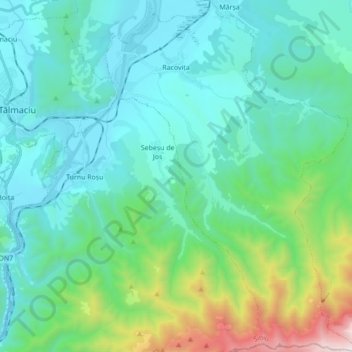
Name: Topografische Karte Racovița, Höhe, Relief.
Ort: Racovița, Sibiu, Romania (45.58117 24.30931 45.70228 24.43388)
Durchschnittliche Höhe: 674 m
Minimale Höhe: 350 m
Maximale Höhe: 2’119 m
Racovița Commune is situated at the base of Suru Peak (2,281 m or 7,484 ft) on the contact between the foothills of the Făgăraș Mountains and the low terrace of the floodplain, on the left bank of the river Olt, at an altitude of 385 meters. The commune borders to the north and northeast with the town Avrig; the border, which extends from the confluence of the small river Mârșa with the Olt to the Sorliței Peak, was established after the year 1200 and is marked with border signs called 'morminți'.
Andere topografische Karten
Klicken Sie auf eine Karte, um ihre Topografie, ihre Höhe und ihr Relief anzuzeigen.
Bâlea Lake
Romania > Sibiu > Cârțișoara
Bâlea Lake, Cârțișoara, Sibiu, Romania
Durchschnittliche Höhe: 2’080 m
Lacul fără fund
Romania > Sibiu > Ocna Sibiului > Ocna Sibiului
Lacul fără fund, Ocna Sibiului, Sibiu, Romania
Durchschnittliche Höhe: 414 m
Miercurea Sibiului
Romania > Sibiu > Miercurea Sibiului
Miercurea Sibiului, Sibiu, Romania
Durchschnittliche Höhe: 432 m
Porumbacu
Romania > Sibiu > Porumbacu de Jos
Porumbacu, Porumbacu de Jos, Sibiu, 557192, Romania
Durchschnittliche Höhe: 466 m
Merghindeal
Romania > Sibiu > Merghindeal
Merghindeal, Sibiu, 557140, Romania
Durchschnittliche Höhe: 507 m
Cârțișoara
Romania > Sibiu > Cârțișoara
Cârțișoara, Sibiu, 557075, Romania
Durchschnittliche Höhe: 501 m