
Topografische Karte Lawton
Interaktive Karte
Klicken Sie auf die Karte, um die Höhe anzuzeigen.
Über diese Karte
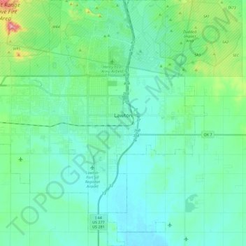
Name: Topografische Karte Lawton, Höhe, Relief.
Ort: Lawton, Comanche County, Oklahoma, United States (34.51150 -98.53649 34.69435 -98.31443)
Durchschnittliche Höhe: 352 m
Minimale Höhe: 314 m
Maximale Höhe: 525 m
Developed on former reservation lands of the Kiowa, Comanche, and Apache Indians, Lawton was founded by European Americans on 6 August 1901. It was named after Major General Henry Ware Lawton, who served in the Civil War, where he earned the Medal of Honor, and was killed in action in the Philippine–American War. Lawton's landscape is typical of the Great Plains, with flat topography and gently rolling hills, while the area north of the city is marked by the Wichita Mountains.
Andere topografische Karten
Klicken Sie auf eine Karte, um ihre Topografie, ihre Höhe und ihr Relief anzuzeigen.
Daly Hill
United States > Oklahoma > Comanche County
Daly Hill, Comanche County, Oklahoma, United States
Durchschnittliche Höhe: 396 m
Jackson Hole
United States > Oklahoma > Comanche County
Jackson Hole, Comanche County, Oklahoma, United States
Durchschnittliche Höhe: 406 m
South East Corner Landing Strip
United States > Oklahoma > Comanche County
South East Corner Landing Strip, Comanche County, Oklahoma, United States
Durchschnittliche Höhe: 383 m
Mount McKinley
United States > Oklahoma > Comanche County
Mount McKinley, Comanche County, Oklahoma, United States
Durchschnittliche Höhe: 498 m
Fort Sill
United States > Oklahoma > Comanche County
Fort Sill, Comanche County, Oklahoma, United States
Durchschnittliche Höhe: 417 m
Medicine Park
United States > Oklahoma > Comanche County > Medicine Park
Medicine Park, Comanche County, Oklahoma, 73557, United States
Durchschnittliche Höhe: 429 m