
Topografische Karte Treasure County
Interaktive Karte
Klicken Sie auf die Karte, um die Höhe anzuzeigen.
Über diese Karte
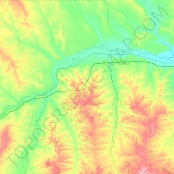
Name: Topografische Karte Treasure County, Höhe, Relief.
Ort: Treasure County, Montana, United States (45.86984 -107.73837 46.48247 -106.93902)
Durchschnittliche Höhe: 927 m
Minimale Höhe: 773 m
Maximale Höhe: 1’278 m
Andere topografische Karten
Klicken Sie auf eine Karte, um ihre Topografie, ihre Höhe und ihr Relief anzuzeigen.
Butte
United States > Montana > Silver Bow County
Butte, Silver Bow County, Montana, United States
Durchschnittliche Höhe: 1’909 m
Missoula
United States > Montana > Missoula County
Missoula, Missoula County, Montana, United States
Durchschnittliche Höhe: 1’173 m
Kalispell
United States > Montana > Flathead County
Kalispell, Flathead County, Montana, United States
Durchschnittliche Höhe: 934 m
Logan
United States > Montana > Gallatin County
Logan, Gallatin County, Montana, United States
Durchschnittliche Höhe: 1’294 m
Trego
United States > Montana > Lincoln County
Trego, Lincoln County, Montana, 59934, United States
Durchschnittliche Höhe: 974 m
Stillwater County
Stillwater County, Montana, United States
Durchschnittliche Höhe: 1’474 m
Carr Trailer Court
United States > Montana > Stillwater County > Columbus
Carr Trailer Court, Columbus, Stillwater County, Montana, United States
Durchschnittliche Höhe: 1’119 m
Franklin Park
United States > Montana > Missoula County > Missoula
Franklin Park, Franklin to the Fort, Missoula, Missoula County, Montana, United States
Durchschnittliche Höhe: 968 m
Red Rock River
United States > Montana > Beaverhead County > Dell
Red Rock River, Dell, Beaverhead County, Montana, United States
Durchschnittliche Höhe: 1’834 m
Jackson
United States > Montana > Beaverhead County
Jackson, Beaverhead County, Montana, 59736, United States
Durchschnittliche Höhe: 1’995 m
Flathead County
Flathead County, Montana, United States
Durchschnittliche Höhe: 1’497 m
Lois Lake
United States > Montana > Powell County
Lois Lake, Powell County, Montana, United States
Durchschnittliche Höhe: 1’671 m
Twin Bridges
United States > Montana > Madison County
Twin Bridges, Madison County, Montana, United States
Durchschnittliche Höhe: 1’414 m
Lakeside
United States > Montana > Flathead County
Lakeside, Flathead County, Montana, 59922, United States
Durchschnittliche Höhe: 1’034 m
Rattlesnake Wilderness
United States > Montana > Missoula County
Rattlesnake Wilderness, Missoula County, Montana, United States
Durchschnittliche Höhe: 1’847 m
Roosevelt County
Roosevelt County, Montana, United States
Durchschnittliche Höhe: 703 m
Wild Horse Island
United States > Montana > Lake County
Wild Horse Island, Lake County, Montana, United States
Durchschnittliche Höhe: 916 m
Red Lodge
United States > Montana > Carbon County
Red Lodge, Carbon County, Montana, 59068, United States
Durchschnittliche Höhe: 1’720 m
Victor
United States > Montana > Ravalli County
Victor, Ravalli County, Montana, United States
Durchschnittliche Höhe: 1’047 m
Winston
United States > Montana > Broadwater County > Winston
Winston, Broadwater County, Montana, 59647, United States
Durchschnittliche Höhe: 1’335 m
Lake County
Lake County, Montana, United States
Durchschnittliche Höhe: 1’343 m
Jefferson County
Jefferson County, Montana, United States
Durchschnittliche Höhe: 1’750 m
Petroleum County
Petroleum County, Montana, United States
Durchschnittliche Höhe: 916 m
Thompson Park
United States > Montana > Silver Bow County > Butte
Thompson Park, Butte, Silver Bow County, Montana, United States
Durchschnittliche Höhe: 1’870 m
Baldy
United States > Montana > Powell County
Baldy, Powell County, Montana, United States
Durchschnittliche Höhe: 2’473 m
Riata Park
United States > Montana > Missoula County > Missoula
Riata Park, 44 Ranch, Orchard Homes, Missoula, Missoula County, Montana, United States
Durchschnittliche Höhe: 961 m
Wisdom
United States > Montana > Beaverhead County > Wisdom
Wisdom, Beaverhead County, Montana, 59761, United States
Durchschnittliche Höhe: 1’848 m
Ashenhurst Number 2 Dam
United States > Montana > Rosebud County
Ashenhurst Number 2 Dam, Rosebud County, Montana, United States
Durchschnittliche Höhe: 955 m
Baker
United States > Montana > Fallon County
Baker, Fallon County, Montana, 59313, United States
Durchschnittliche Höhe: 901 m
Sugar Loaf Mountain
United States > Montana > Park County
Sugar Loaf Mountain, Park County, Montana, United States
Durchschnittliche Höhe: 2’343 m
McLeod
United States > Montana > Sweet Grass County
McLeod, Sweet Grass County, Montana, United States
Durchschnittliche Höhe: 1’564 m
Hysham
United States > Montana > Treasure County
Hysham, Treasure County, Montana, United States
Durchschnittliche Höhe: 810 m
St. Regis
United States > Montana > Mineral County
St. Regis, Mineral County, Montana, 59866, United States
Durchschnittliche Höhe: 838 m
Seeley Lake
United States > Montana > Missoula County
Seeley Lake, Missoula County, Montana, United States
Durchschnittliche Höhe: 1’348 m
Pray Lake
United States > Montana > Glacier County
Pray Lake, Glacier County, Montana, United States
Durchschnittliche Höhe: 1’717 m
Baseline
United States > Montana > Yellowstone County
Baseline, Yellowstone County, Montana, 59103, United States
Durchschnittliche Höhe: 1’043 m
Ski Hill
United States > Montana > Beaverhead County
Ski Hill, Beaverhead County, Montana, United States
Durchschnittliche Höhe: 2’215 m
Bowman Lake
United States > Montana > Flathead County
Bowman Lake, Flathead County, Montana, United States
Durchschnittliche Höhe: 1’639 m
Livingston
United States > Montana > Park County
Livingston, Park County, Montana, United States
Durchschnittliche Höhe: 1’421 m
Poplar
United States > Montana > Roosevelt County
Poplar, Poplar District, Roosevelt County, Montana, United States
Durchschnittliche Höhe: 600 m
Choteau
United States > Montana > Teton County
Choteau, Teton County, Montana, United States
Durchschnittliche Höhe: 1’173 m
Plains
United States > Montana > Sanders County
Plains, Sanders County, Montana, United States
Durchschnittliche Höhe: 775 m
Bozeman
United States > Montana > Gallatin County
Bozeman, Gallatin County, Montana, United States
Durchschnittliche Höhe: 1’495 m
Wolf Creek
United States > Montana > Lincoln County
Wolf Creek, Lincoln County, Montana, United States
Durchschnittliche Höhe: 1’225 m
Gluten
United States > Montana > Daniels County
Gluten, Daniels County, Montana, United States
Durchschnittliche Höhe: 816 m
Ozone Layer Dam
United States > Montana > Wheatland County
Ozone Layer Dam, Wheatland County, Montana, United States
Durchschnittliche Höhe: 1’413 m
Emigrant
United States > Montana > Park County
Emigrant, Park County, Montana, 59027, United States
Durchschnittliche Höhe: 1’530 m
Martin City
United States > Montana > Flathead County > Martin City
Martin City, Flathead County, Montana, 59926, United States
Durchschnittliche Höhe: 989 m
Ear Mountain
United States > Montana > Teton County
Ear Mountain, Teton County, Montana, United States
Durchschnittliche Höhe: 2’138 m
Columbia Falls
United States > Montana > Flathead County
Columbia Falls, Flathead County, Montana, 59912, United States
Durchschnittliche Höhe: 934 m