
Topografische Karte Nebraska
Interaktive Karte
Klicken Sie auf die Karte, um die Höhe anzuzeigen.
Über diese Karte
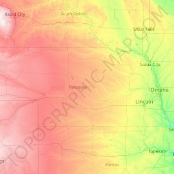
Name: Topografische Karte Nebraska, Höhe, Relief.
Ort: Nebraska, United States (39.99998 -104.05352 43.00127 -95.30805)
Durchschnittliche Höhe: 747 m
Minimale Höhe: 255 m
Maximale Höhe: 2’159 m
Nebraska is composed of two major land regions: the Dissected Till Plains and the Great Plains. The easternmost portion of the state was scoured by Ice Age glaciers; the Dissected Till Plains were left after the glaciers retreated. The Dissected Till Plains is a region of gently rolling hills; Omaha and Lincoln are in this region. The Great Plains occupy most of western Nebraska, with the region consisting of several smaller, diverse land regions, including the Sandhills, the Pine Ridge, the Rainwater Basin, the High Plains and the Wildcat Hills. Panorama Point, at 5,424 feet (1,653 m), is Nebraska's highest point; though despite its name and elevation, it is a relatively low rise near the Colorado and Wyoming borders. A past tourism slogan for the state of Nebraska was "Where the West Begins" (it has since been changed to "Honestly, it's not for everyone"). Locations given for the beginning of the "West" in Nebraska include the Missouri River, the intersection of 13th and O Streets in Lincoln (where it is marked by a red brick star), the 100th meridian, and Chimney Rock.
Andere topografische Karten
Klicken Sie auf eine Karte, um ihre Topografie, ihre Höhe und ihr Relief anzuzeigen.
Houston
United States > Texas > Harris County
Houston, Harris County, Texas, United States
Durchschnittliche Höhe: 25 m
Montgomery County
Montgomery County, Texas, United States
Durchschnittliche Höhe: 69 m
The Woodlands
United States > Texas > Montgomery County
The Woodlands, Montgomery County, Texas, United States
Durchschnittliche Höhe: 47 m
Boulder
United States > Colorado > Boulder County
Boulder, Boulder County, Colorado, United States
Durchschnittliche Höhe: 1’785 m
Los Angeles
Los Angeles, California, United States
Durchschnittliche Höhe: 241 m
Brooklyn
United States > New York > New York
Brooklyn, Kings County, New York, United States
Durchschnittliche Höhe: 9 m
Knoxville
United States > Tennessee > Knox County
Knoxville, Knox County, East Tennessee, Tennessee, United States
Durchschnittliche Höhe: 307 m
New Orleans
United States > Louisiana > Orleans Parish
New Orleans, Orleans Parish, Louisiana, United States
Durchschnittliche Höhe: 1 m
Sequoia National Park
United States > California > Tulare County
Sequoia National Park, Tulare County, California, United States
Durchschnittliche Höhe: 2’515 m
Yosemite National Park
Yosemite National Park, California, United States
Durchschnittliche Höhe: 2’337 m
Brunswick County
United States > North Carolina
Brunswick County, North Carolina, United States
Durchschnittliche Höhe: 9 m
Black Hills
United States > South Dakota > Pennington County
Black Hills, Pennington County, South Dakota, United States
Durchschnittliche Höhe: 1’894 m
Appalachian Mountains
United States > North Carolina > Yancey County
Appalachian Mountains, Yancey County, North Carolina, United States
Durchschnittliche Höhe: 1’463 m
Santa Barbara
United States > California > Santa Barbara County
Santa Barbara, Santa Barbara County, California, United States
Durchschnittliche Höhe: 119 m
Queens County
United States > New York > New York
Queens County, New York, United States
Durchschnittliche Höhe: 11 m
Boston
United States > Massachusetts > Suffolk County
Boston, Suffolk County, Massachusetts, United States
Durchschnittliche Höhe: 25 m
Nassau County
Nassau County, New York, United States
Durchschnittliche Höhe: 18 m
College Station
United States > Texas > Brazos County
College Station, Brazos County, Texas, United States
Durchschnittliche Höhe: 87 m
Santa Fe
United States > New Mexico > Santa Fe County
Santa Fe, Santa Fe County, New Mexico, United States
Durchschnittliche Höhe: 2’221 m