
Topografische Karte Letchworth
Klicken Sie auf die Karte, um die Höhe anzuzeigen.
Über diese Karte
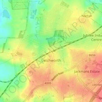
Name: Topografische Karte Letchworth, Höhe, Relief.
Ort: Letchworth, Hertfordshire, England, United Kingdom (51.96105 -0.25510 51.99937 -0.19579)
Durchschnittliche Höhe: 81 m
Minimale Höhe: 48 m
Maximale Höhe: 110 m
Andere topografische Karten
Klicken Sie auf eine Karte, um ihre Topografie, ihre Höhe und ihr Relief anzuzeigen.
Berkhamsted
United Kingdom > England > Hertfordshire > Dacorum > Northchurch
The layout of Berkhamsted's centre is typical of a medieval market settlement: the linear High Street (aligned on the Akeman Street) forms the spine of the town (roughly aligned east–west), from which extend medieval burgage plots (to the north and south). The surviving burgage plot layout is the result of a…
Durchschnittliche Höhe: 142 m
Welwyn Garden City
United Kingdom > England > Hertfordshire > Welwyn Hatfield
Durchschnittliche Höhe: 89 m
Waterford
United Kingdom > England > Hertfordshire > East Hertfordshire > Waterford
Durchschnittliche Höhe: 66 m
Bentley Heath
United Kingdom > England > Hertfordshire > Hertsmere > Potters Bar
Durchschnittliche Höhe: 105 m
Elstree
United Kingdom > England > Hertfordshire > Hertsmere
In 1723, topographer John Norden noted in his book Speculum Britanniae, that in the county of Hartfordshire [sic] was one "Elstre or Eglestre". In an earlier edition, he writes.
Durchschnittliche Höhe: 105 m
Cold Christmas
United Kingdom > England > Hertfordshire > East Hertfordshire
Durchschnittliche Höhe: 72 m
Letty Green
United Kingdom > England > Hertfordshire > East Hertfordshire
Durchschnittliche Höhe: 69 m
Spellbrook
United Kingdom > England > Hertfordshire > East Hertfordshire > Sawbridgeworth
Durchschnittliche Höhe: 71 m
Little Amwell
United Kingdom > England > Hertfordshire > East Hertfordshire
Durchschnittliche Höhe: 65 m
Broken Green
United Kingdom > England > Hertfordshire > East Hertfordshire
Durchschnittliche Höhe: 97 m
St Ippolyts
United Kingdom > England > Hertfordshire > North Hertfordshire
Durchschnittliche Höhe: 103 m
Hertingfordbury
United Kingdom > England > Hertfordshire > East Hertfordshire
Durchschnittliche Höhe: 61 m
Letchworth
United Kingdom > England > Hertfordshire > North Hertfordshire > Letchworth
Durchschnittliche Höhe: 80 m
Croxley Green
United Kingdom > England > Hertfordshire > Three Rivers > Rickmansworth
Durchschnittliche Höhe: 67 m
Sarratt
United Kingdom > England > Hertfordshire > Three Rivers > Sarratt
Durchschnittliche Höhe: 107 m
Ashbrook
United Kingdom > England > Hertfordshire > North Hertfordshire > St Ippolyts
Durchschnittliche Höhe: 85 m
Perry Green
United Kingdom > England > Hertfordshire > East Hertfordshire
Durchschnittliche Höhe: 78 m
St Albans
United Kingdom > England > Hertfordshire
St Albans was an ancient borough created following the dissolution of the monastery in 1539. It consisted of the ancient parish of St Albans (also known as the Abbey parish) and parts of St Michael and St Peter. The municipal corporation was reformed by the Municipal Corporations Act 1835 and the boundary was…
Durchschnittliche Höhe: 107 m
Thorley
United Kingdom > England > Hertfordshire > East Hertfordshire > Thorley
Durchschnittliche Höhe: 82 m
Long Marston
United Kingdom > England > Hertfordshire > Dacorum > Long Marston
Durchschnittliche Höhe: 92 m
Sawbridgeworth
United Kingdom > England > Hertfordshire > East Hertfordshire > Sawbridgeworth
Durchschnittliche Höhe: 67 m
Standon
United Kingdom > England > Hertfordshire > East Hertfordshire > Standon
Durchschnittliche Höhe: 97 m
Knebworth
United Kingdom > England > Hertfordshire > North Hertfordshire
Durchschnittliche Höhe: 103 m
Newnham
United Kingdom > England > Hertfordshire > North Hertfordshire > Baldock
Durchschnittliche Höhe: 69 m
Buntingford
United Kingdom > England > Hertfordshire > East Hertfordshire > Buntingford
Durchschnittliche Höhe: 110 m
Bishop's Stortford
United Kingdom > England > Hertfordshire > East Hertfordshire > Thorley
Stortford, along with the rest of Britain, has a temperate maritime climate, with cool summers and mild winters. The nearest weather station for which averages and extremes are available is Stansted Airport, about 2+1⁄2 miles (4 kilometres) due east of Stortford's town centre. Located at an elevation of over…
Durchschnittliche Höhe: 83 m
Tewin
United Kingdom > England > Hertfordshire > East Hertfordshire > Tewin
Durchschnittliche Höhe: 91 m
Therfield
United Kingdom > England > Hertfordshire > North Hertfordshire
Durchschnittliche Höhe: 122 m
St Albans
United Kingdom > England > Hertfordshire
The borough consisted of the ancient parish of St Albans (also known as the Abbey parish) and parts of the parishes of St Michael and St Peter. The borough was reformed by the Municipal Corporations Act 1835 to become a municipal borough, and the boundary was adjusted to additionally include part of the parish…
Durchschnittliche Höhe: 103 m
Astrope
United Kingdom > England > Hertfordshire > Dacorum > Long Marston
Durchschnittliche Höhe: 91 m
Nomansland
United Kingdom > England > Hertfordshire > St Albans > Sandridge
Durchschnittliche Höhe: 105 m
Primrosehill
United Kingdom > England > Hertfordshire > Three Rivers > Abbots Langley
Durchschnittliche Höhe: 111 m
Throcking
United Kingdom > England > Hertfordshire > East Hertfordshire > Buntingford
Durchschnittliche Höhe: 126 m