
Topografische Karte Carroll County
Interaktive Karte
Klicken Sie auf die Karte, um die Höhe anzuzeigen.
Über diese Karte
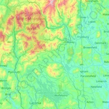
Name: Topografische Karte Carroll County, Höhe, Relief.
Ort: Carroll County, New Hampshire, United States (43.48219 -71.56460 44.28480 -70.95064)
Durchschnittliche Höhe: 356 m
Minimale Höhe: 66 m
Maximale Höhe: 1’902 m
Andere topografische Karten
Klicken Sie auf eine Karte, um ihre Topografie, ihre Höhe und ihr Relief anzuzeigen.
Eaton
United States > New Hampshire > Carroll County
Eaton, Carroll County, New Hampshire, 03832, United States
Durchschnittliche Höhe: 262 m
Stoddard
United States > New Hampshire > Cheshire County
Stoddard, Cheshire County, New Hampshire, United States
Durchschnittliche Höhe: 451 m
Lyman
United States > New Hampshire > Grafton County
Lyman, Grafton County, New Hampshire, United States
Durchschnittliche Höhe: 347 m
Chesterfield
United States > New Hampshire > Cheshire County
Chesterfield, Cheshire County, New Hampshire, United States
Durchschnittliche Höhe: 229 m
Plainfield
United States > New Hampshire > Sullivan County
Plainfield, Sullivan County, New Hampshire, United States
Durchschnittliche Höhe: 267 m
Mount Washington
United States > New Hampshire > Coos County
Mount Washington, Coös County, New Hampshire, United States
Durchschnittliche Höhe: 1’568 m
Washington
United States > New Hampshire > Sullivan County
Washington, Sullivan County, New Hampshire, 03280, United States
Durchschnittliche Höhe: 466 m
Wilmot
United States > New Hampshire > Merrimack County
Wilmot, Merrimack County, New Hampshire, United States
Durchschnittliche Höhe: 364 m
New London
United States > New Hampshire > Merrimack County
New London, Merrimack County, New Hampshire, United States
Durchschnittliche Höhe: 365 m
Harrisville
United States > New Hampshire > Cheshire County
Harrisville, Cheshire County, New Hampshire, 03450, United States
Durchschnittliche Höhe: 422 m
Ossipee
United States > New Hampshire > Carroll County
Ossipee, Carroll County, New Hampshire, United States
Durchschnittliche Höhe: 217 m
Gilboa Mountain
United States > New Hampshire > Cheshire County > Westmoreland
Gilboa Mountain, Westmoreland, Cheshire County, New Hampshire, 03467, United States
Durchschnittliche Höhe: 331 m
Warren
United States > New Hampshire > Grafton County
Warren, Grafton County, New Hampshire, United States
Durchschnittliche Höhe: 475 m
Bonsai
United States > New Hampshire > Grafton County > Rumney
Bonsai, Rumney, Grafton County, New Hampshire, 03266, United States
Durchschnittliche Höhe: 246 m
Rollinsford
United States > New Hampshire > Strafford County
Rollinsford, Strafford County, New Hampshire, 03869, United States
Durchschnittliche Höhe: 32 m
Franconia
United States > New Hampshire > Grafton County
Franconia, Grafton County, New Hampshire, 03580, United States
Durchschnittliche Höhe: 558 m
Westmoreland
United States > New Hampshire > Cheshire County
Westmoreland, Cheshire County, New Hampshire, 03467, United States
Durchschnittliche Höhe: 228 m
Waterville Valley
United States > New Hampshire > Grafton County
Waterville Valley, Grafton County, New Hampshire, 03215, United States
Durchschnittliche Höhe: 649 m
Groton
United States > New Hampshire > Grafton County
Groton, Grafton County, New Hampshire, United States
Durchschnittliche Höhe: 366 m
Millsfield
United States > New Hampshire > Coos County
Millsfield, Coös County, New Hampshire, United States
Durchschnittliche Höhe: 583 m
Somersworth
United States > New Hampshire > Strafford County
Somersworth, Strafford County, New Hampshire, 03878, United States
Durchschnittliche Höhe: 56 m
Suncook
United States > New Hampshire > Merrimack County > Pembroke
Suncook, Pembroke, Merrimack County, New Hampshire, 03275, United States
Durchschnittliche Höhe: 93 m
Sandwich
United States > New Hampshire > Carroll County
Sandwich, Carroll County, New Hampshire, 03259, United States
Durchschnittliche Höhe: 373 m
Plymouth
United States > New Hampshire > Grafton County
Plymouth, Grafton County, New Hampshire, 03264, United States
Durchschnittliche Höhe: 264 m
Brookline
United States > New Hampshire > Hillsborough County
Brookline, Hillsborough County, New Hampshire, 03033, United States
Durchschnittliche Höhe: 126 m
Milford
United States > New Hampshire > Hillsborough County
Milford, Hillsborough County, New Hampshire, 03055, United States
Durchschnittliche Höhe: 114 m
Peterborough
United States > New Hampshire > Hillsborough County
Peterborough, Hillsborough County, New Hampshire, United States
Durchschnittliche Höhe: 304 m
East Kingston
United States > New Hampshire > Rockingham County
East Kingston, Rockingham County, New Hampshire, United States
Durchschnittliche Höhe: 38 m
Jefferson Highland
United States > New Hampshire > Coos County > Jefferson
Jefferson Highland, Jefferson, Coös County, New Hampshire, 03583, United States
Durchschnittliche Höhe: 451 m
New Durham
United States > New Hampshire > Strafford County
New Durham, Strafford County, New Hampshire, 03855, United States
Durchschnittliche Höhe: 228 m
Wentworth
United States > New Hampshire > Grafton County
Wentworth, Grafton County, New Hampshire, 03282, United States
Durchschnittliche Höhe: 422 m
Jefferson
United States > New Hampshire > Coos County
Jefferson, Coös County, New Hampshire, 03583, United States
Durchschnittliche Höhe: 493 m
Flat Mountain
United States > New Hampshire > Carroll County > Sandwich
Flat Mountain, Sandwich, Carroll County, New Hampshire, United States
Durchschnittliche Höhe: 629 m
Moultonborough
United States > New Hampshire > Carroll County
Moultonborough, Carroll County, New Hampshire, United States
Durchschnittliche Höhe: 243 m
Bath
United States > New Hampshire > Grafton County
Bath, Grafton County, New Hampshire, 03740, United States
Durchschnittliche Höhe: 289 m
Albany
United States > New Hampshire > Carroll County > Albany
Albany, Carroll County, New Hampshire, United States
Durchschnittliche Höhe: 276 m
Unity
United States > New Hampshire > Sullivan County
Unity, Sullivan County, New Hampshire, United States
Durchschnittliche Höhe: 369 m
Alstead
United States > New Hampshire > Cheshire County
Alstead, Cheshire County, New Hampshire, United States
Durchschnittliche Höhe: 289 m
Bennington
United States > New Hampshire > Hillsborough County
Bennington, Hillsborough County, New Hampshire, 03442, United States
Durchschnittliche Höhe: 260 m
Providence Hill
United States > New Hampshire > Rockingham County > Atkinson
Providence Hill, Atkinson, Rockingham County, New Hampshire, 03811, United States
Durchschnittliche Höhe: 72 m
Hillsboro Lower Village
United States > New Hampshire > Hillsborough County > Hillsborough
Hillsboro Lower Village, Hillsborough, Hillsborough County, New Hampshire, 03244, United States
Durchschnittliche Höhe: 242 m
Hampstead
United States > New Hampshire > Rockingham County
Hampstead, Rockingham County, New Hampshire, United States
Durchschnittliche Höhe: 81 m
Lake Winnipesaukee
United States > New Hampshire > Belknap County > Alton
Lake Winnipesaukee, Alton, Belknap County, New Hampshire, 03226, United States
Durchschnittliche Höhe: 223 m
Auburn
United States > New Hampshire > Rockingham County
Auburn, Rockingham County, New Hampshire, 03032, United States
Durchschnittliche Höhe: 107 m
North Haverhill
United States > New Hampshire > Grafton County > Haverhill
North Haverhill, Haverhill, Grafton County, New Hampshire, 03774, United States
Durchschnittliche Höhe: 149 m
Stinson Lake
United States > New Hampshire > Grafton County > Rumney > Stinson Lake
Stinson Lake, Rumney, Grafton County, New Hampshire, United States
Durchschnittliche Höhe: 460 m
Echo Lake
United States > New Hampshire > Grafton County > Franconia
Echo Lake, Franconia, Grafton County, New Hampshire, United States
Durchschnittliche Höhe: 693 m
Blake Islands
United States > New Hampshire > Coos County > Errol
Blake Islands, Errol, Coös County, New Hampshire, United States
Durchschnittliche Höhe: 530 m
Bayle Mountain
United States > New Hampshire > Carroll County > Ossipee
Bayle Mountain, Ossipee, Carroll County, New Hampshire, United States
Durchschnittliche Höhe: 405 m
Grafton County
Grafton County, New Hampshire, United States
Durchschnittliche Höhe: 424 m